Rusinów geodata
Rusinów (Mazovia) is a seat of a third-order administrative division; located in Poland in Europe/Warsaw (GMT+2) time zone. With population of 751 people, there are 2951 cities with bigger population in this country. Compared to other cities in Poland, 55.3% of cities are located further ↓South; 66.2% of cities are located further ←West and 50.8% of cities have higher elevation than Rusinów. Note1


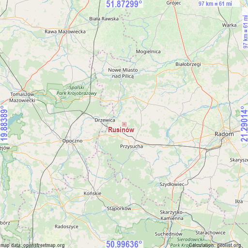
Rusinów GPS coordinates[2]
51° 26' 12.408" North, 20° 35' 13.236" East
| Map corner | latitude | longitude |
|---|---|---|
| Upper-left | 51.87299°, | 19.88389° |
| Center: | 51.43678°, | 20.58701° |
| Lower-right: | 50.99636°, | 21.29014° |
| Map W x H: | 97.5×97.5 km | = 60.6×60.6mi |
| max Lat: | 54.83135° ⇑44.7% North |
| Rusinów: | 51.43678° |
| min Lat: | ⇓55.3% South 49.21328° |
| min Long | Rusinów | max Long |
| 14.20249° | 20.58701° | 24.03723° |
| W 66.2%⇐ | ⇒33.8% E |
Elevation
Elevation of Rusinów is 170 m = 558 ft, and this is 21.4 m = 70 ft below average elevation for this country.
| Max E: |
974 m = 3196 ft | 50.8% |
| Avg. | 191.4 m = 628 ft | |
| Rusinów | 170 m = 558 ft | |
Min E: |
-3 m = -10 ft | 49.2% |
See also: Poland elevation on elevation.city.
Geographical zone
Rusinów is located in North temperate zone (between Tropic of Cancer and the Arctic Circle). Distance of this North polar circle is 1681.9 km =1045.1 mi to North.| Distance of | km | miles | from Rusinów |
|---|---|---|---|
| North Pole | 4287.8 | 2664.3 | to North |
| Arctic Circle | 1681.9 | 1045.1 | to North |
| Tropic Cancer | 3113.3 | 1934.5 | to South |
| Equator | 5719.2 | 3553.7 | to South |


Nearby cities:
15 places around Rusinów: (largest is in red/bold)
• Borkowice
14.6 km =9.1 mi,  152°
152°
• Bukowiec Opoczyński
22.4 km =13.9 mi,  264°
264°
• Drzewica
7.8 km =4.8 mi,  281°
281°
• Gielniów
8.4 km =5.2 mi,  241°
241°
• Gowarczów
20.4 km =12.7 mi,  210°
210°
• Klwów
11.4 km =7.1 mi,  17°
17°
• Mroczków Gościnny
15 km =9.3 mi,  245°
245°
• Nowe Miasto nad Pilicą
20.2 km =12.6 mi,  357°
357°
• Odrzywół
9.5 km =5.9 mi,  346°
346°
• Potworów
12.3 km =7.6 mi,  49°
49°
• Poświętne
18.7 km =11.6 mi,  304°
304°
• Przysucha
9.2 km =5.7 mi,  161°
161°
• Przytyk
22.3 km =13.9 mi,  81°
81°
• Wieniawa
16.7 km =10.4 mi,  120°
120°
• Wola Załężna
19.3 km =12 mi, 255°
Sources, notices
• [Note1] Compared only with cities in Poland existing in our database
• [Src1] Map data: © OpenStreetMap contributors (CC-BY-SA)
• [Src2] Other city data from geonames.org with taken over terms of usage.
• [Src3] Geographical zone / Annual Mean Temperature by Robert A. Rohde @ Wikipedia
