Dobra geodata
Dobra (Lesser Poland) is a seat of a third-order administrative division; located in Poland in Europe/Warsaw (GMT+2) time zone. With population of 3,100 people, there are 1018 cities with bigger population in this country. Compared to other cities in Poland, 94.1% of cities are located further ↑North; 61.9% of cities are located further ←West and 96.2% of cities have lower elevation than Dobra. Note1


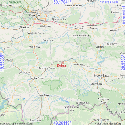
Dobra GPS coordinates[2]
49° 43' 4.548" North, 20° 15' 12.492" East
| Map corner | latitude | longitude |
|---|---|---|
| Upper-left | 50.17041°, | 19.55035° |
| Center: | 49.71793°, | 20.25347° |
| Lower-right: | 49.26119°, | 20.9566° |
| Map W x H: | 101.1×101.1 km | = 62.8×62.8mi |
| max Lat: | 54.83135° ⇑94.1% North |
| Dobra: | 49.71793° |
| min Lat: | ⇓5.9% South 49.21328° |
| min Long | Dobra | max Long |
| 14.20249° | 20.25347° | 24.03723° |
| W 61.9%⇐ | ⇒38.1% E |
Elevation
Elevation of Dobra is 448 m = 1470 ft, and this is 256.6 m = 842 ft above average elevation for this country.
| Max E: |
974 m = 3196 ft | 3.8% |
| Dobra | 448 m 1470 ft | |
| Avg. | 191.4 m = 628 ft | |
Min E: |
-3 m = -10 ft | 96.2% |
See also: Poland elevation on elevation.city.
Geographical zone
Dobra is located in North temperate zone (between Tropic of Cancer and the Arctic Circle). Distance of this North polar circle is 1873.1 km =1163.9 mi to North.| Distance of | km | miles | from Dobra |
|---|---|---|---|
| North Pole | 4478.9 | 2783.1 | to North |
| Arctic Circle | 1873.1 | 1163.9 | to North |
| Tropic Cancer | 2922.2 | 1815.8 | to South |
| Equator | 5528.1 | 3435 | to South |


Nearby cities:
15 places around Dobra: (largest is in red/bold)
• Jodłownik
6.5 km =4 mi,  349°
349°
• Kasina Wielka
8.6 km =5.3 mi,  278°
278°
• Krasne-Lasocice
10.7 km =6.6 mi, 350°
• Laskowa
15 km =9.3 mi,  71°
71°
• Limanowa
12.2 km =7.6 mi,  96°
96°
• Lipnik
14.5 km =9 mi,  303°
303°
• Lubomierz
12.7 km =7.9 mi,  196°
196°
• Mszana Dolna
13.4 km =8.3 mi,  248°
248°
• Mszana Górna
12.8 km =8 mi,  241°
241°
• Skrzydlna
6.2 km =3.9 mi,  309°
309°
• Słopnice
7.4 km =4.6 mi,  119°
119°
• Tymbark
5.3 km =3.3 mi,  77°
77°
• Wilczyce
6.8 km =4.2 mi,  213°
213°
• Wiśniowa
12.6 km =7.8 mi, 307°
• Węglówka
12.2 km =7.6 mi, 278°
Sources, notices
• [Note1] Compared only with cities in Poland existing in our database
• [Src1] Map data: © OpenStreetMap contributors (CC-BY-SA)
• [Src2] Other city data from geonames.org with taken over terms of usage.
• [Src3] Geographical zone / Annual Mean Temperature by Robert A. Rohde @ Wikipedia
