Przyborów geodata
Przyborów (Lesser Poland) is a populated place; located in Poland in Europe/Warsaw (GMT+2) time zone. With population of 1,757 people, there are 1648 cities with bigger population in this country. Compared to other cities in Poland, 80.8% of cities are located further ↑North; 66.9% of cities are located further ←West and 57.7% of cities have lower elevation than Przyborów. Note1


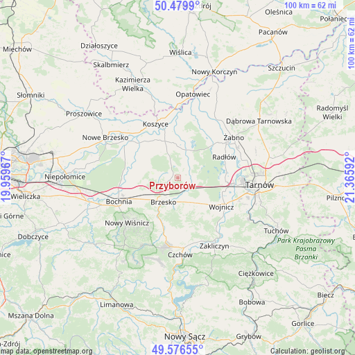
Przyborów GPS coordinates[2]
50° 1' 49.26" North, 20° 39' 46.044" East
| Map corner | latitude | longitude |
|---|---|---|
| Upper-left | 50.4799°, | 19.95967° |
| Center: | 50.03035°, | 20.66279° |
| Lower-right: | 49.57655°, | 21.36592° |
| Map W x H: | 100.4×100.4 km | = 62.4×62.4mi |
| max Lat: | 54.83135° ⇑80.8% North |
| Przyborów: | 50.03035° |
| min Lat: | ⇓19.2% South 49.21328° |
| min Long | Przyborów | max Long |
| 14.20249° | 20.66279° | 24.03723° |
| W 66.9%⇐ | ⇒33.1% E |
Elevation
Elevation of Przyborów is 193 m = 633 ft, and this is 1.6 m = 5 ft above average elevation for this country.
| Max E: |
974 m = 3196 ft | 42.3% |
| Przyborów | 193 m 633 ft | |
| Avg. | 191.4 m = 628 ft | |
Min E: |
-3 m = -10 ft | 57.7% |
See also: Poland elevation on elevation.city.
Geographical zone
Przyborów is located in North temperate zone (between Tropic of Cancer and the Arctic Circle). Distance of this North polar circle is 1838.3 km =1142.3 mi to North.| Distance of | km | miles | from Przyborów |
|---|---|---|---|
| North Pole | 4444.2 | 2761.5 | to North |
| Arctic Circle | 1838.3 | 1142.3 | to North |
| Tropic Cancer | 2956.9 | 1837.3 | to South |
| Equator | 5562.9 | 3456.6 | to South |


Nearby cities:
15 places around Przyborów: (largest is in red/bold)
• Borek
9.5 km =5.9 mi,  261°
261°
• Borzęcin
5.2 km =3.2 mi,  41°
41°
• Brzesko
7.9 km =4.9 mi,  210°
210°
• Dębno
8.1 km =5 mi,  149°
149°
• Jadowniki
8.1 km =5 mi,  189°
189°
• Jasień
9.3 km =5.8 mi,  224°
224°
• Jodłówka
9.2 km =5.7 mi,  243°
243°
• Maszkienice
4.9 km =3 mi,  159°
159°
• Porąbka Uszewska
10 km =6.2 mi,  168°
168°
• Rudy-Rysie
3.9 km =2.4 mi,  332°
332°
• Sterkowiec
4.1 km =2.5 mi, 161°
• Strzelce Wielkie
9.2 km =5.7 mi,  320°
320°
• Szczepanów
2.9 km =1.8 mi, 192°
• Wokowice
3.8 km =2.4 mi,  134°
134°
• Wola Dębińska
5.6 km =3.5 mi, 161°
Sources, notices
• [Note1] Compared only with cities in Poland existing in our database
• [Src1] Map data: © OpenStreetMap contributors (CC-BY-SA)
• [Src2] Other city data from geonames.org with taken over terms of usage.
• [Src3] Geographical zone / Annual Mean Temperature by Robert A. Rohde @ Wikipedia
