Bieliny geodata
Bieliny (Świętokrzyskie) is a seat of a third-order administrative division; located in Poland in Europe/Warsaw (GMT+2) time zone. With population of 1,900 people, there are 1552 cities with bigger population in this country. Compared to other cities in Poland, 59.1% of cities are located further ↑North; 71.3% of cities are located further ←West and 87.7% of cities have lower elevation than Bieliny. Note1


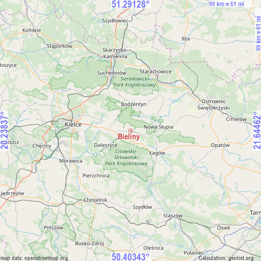
Bieliny GPS coordinates[2]
50° 50' 58.092" North, 20° 56' 29.364" East
| Map corner | latitude | longitude |
|---|---|---|
| Upper-left | 51.29128°, | 20.23837° |
| Center: | 50.84947°, | 20.94149° |
| Lower-right: | 50.40343°, | 21.64462° |
| Map W x H: | 98.7×98.7 km | = 61.3×61.3mi |
| max Lat: | 54.83135° ⇑59.1% North |
| Bieliny: | 50.84947° |
| min Lat: | ⇓40.9% South 49.21328° |
| min Long | Bieliny | max Long |
| 14.20249° | 20.94149° | 24.03723° |
| W 71.3%⇐ | ⇒28.7% E |
Elevation
Elevation of Bieliny is 306 m = 1004 ft, and this is 114.6 m = 376 ft above average elevation for this country.
| Max E: |
974 m = 3196 ft | 12.3% |
| Bieliny | 306 m 1004 ft | |
| Avg. | 191.4 m = 628 ft | |
Min E: |
-3 m = -10 ft | 87.7% |
See also: Poland elevation on elevation.city.
Geographical zone
Bieliny is located in North temperate zone (between Tropic of Cancer and the Arctic Circle). Distance of this North polar circle is 1747.2 km =1085.7 mi to North.| Distance of | km | miles | from Bieliny |
|---|---|---|---|
| North Pole | 4353.1 | 2704.9 | to North |
| Arctic Circle | 1747.2 | 1085.7 | to North |
| Tropic Cancer | 3048 | 1893.9 | to South |
| Equator | 5653.9 | 3513.2 | to South |


Nearby cities:
15 places around Bieliny: (largest is in red/bold)
• Bodzentyn
10.3 km =6.4 mi,  6°
6°
• Daleszyce
10.7 km =6.6 mi,  240°
240°
• Domaszowice
18.4 km =11.4 mi,  278°
278°
• Górno
8.2 km =5.1 mi,  268°
268°
• Gózd
19.4 km =12.1 mi,  320°
320°
• Masłów
16.3 km =10.1 mi,  290°
290°
• Nowa Słupia
10.6 km =6.6 mi,  81°
81°
• Pawłów
17.7 km =11 mi,  45°
45°
• Rzepin Drugi
19.1 km =11.9 mi,  40°
40°
• Rzepin Pierwszy
17.6 km =10.9 mi,  32°
32°
• Sosnówka
11.8 km =7.3 mi,  60°
60°
• Stara Słupia
12.9 km =8 mi, 76°
• Wiśniowa
11.4 km =7.1 mi,  114°
114°
• Wola Jachowa
5.9 km =3.7 mi, 265°
• Łagów
13 km =8.1 mi,  129°
129°
Sources, notices
• [Note1] Compared only with cities in Poland existing in our database
• [Src1] Map data: © OpenStreetMap contributors (CC-BY-SA)
• [Src2] Other city data from geonames.org with taken over terms of usage.
• [Src3] Geographical zone / Annual Mean Temperature by Robert A. Rohde @ Wikipedia
