Wróblowa geodata
Wróblowa (Subcarpathian) is a populated place; located in Poland in Europe/Warsaw (GMT+2) time zone. With population of 565 people, there are 3369 cities with bigger population in this country. Compared to other cities in Poland, 92.1% of cities are located further ↑North; 78% of cities are located further ←West and 69.8% of cities have lower elevation than Wróblowa. Note1


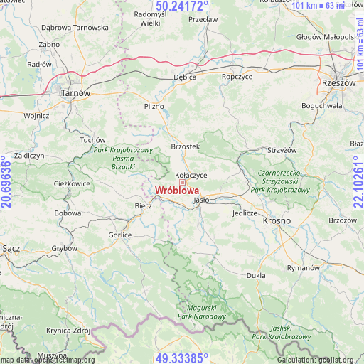
Wróblowa GPS coordinates[2]
49° 47' 23.676" North, 21° 23' 58.128" East
| Map corner | latitude | longitude |
|---|---|---|
| Upper-left | 50.24172°, | 20.69636° |
| Center: | 49.78991°, | 21.39948° |
| Lower-right: | 49.33385°, | 22.10261° |
| Map W x H: | 100.9×100.9 km | = 62.7×62.7mi |
| max Lat: | 54.83135° ⇑92.1% North |
| Wróblowa: | 49.78991° |
| min Lat: | ⇓7.9% South 49.21328° |
| min Long | Wróblowa | max Long |
| 14.20249° | 21.39948° | 24.03723° |
| W 78%⇐ | ⇒22% E |
Elevation
Elevation of Wróblowa is 229 m = 751 ft, and this is 37.6 m = 123 ft above average elevation for this country.
| Max E: |
974 m = 3196 ft | 30.2% |
| Wróblowa | 229 m 751 ft | |
| Avg. | 191.4 m = 628 ft | |
Min E: |
-3 m = -10 ft | 69.8% |
See also: Poland elevation on elevation.city.
Geographical zone
Wróblowa is located in North temperate zone (between Tropic of Cancer and the Arctic Circle). Distance of this North polar circle is 1865.1 km =1158.9 mi to North.| Distance of | km | miles | from Wróblowa |
|---|---|---|---|
| North Pole | 4470.9 | 2778.1 | to North |
| Arctic Circle | 1865.1 | 1158.9 | to North |
| Tropic Cancer | 2930.2 | 1820.7 | to South |
| Equator | 5536.1 | 3440 | to South |


Nearby cities:
15 places around Wróblowa: (largest is in red/bold)
• Biecz
11.5 km =7.1 mi,  238°
238°
• Binarowa
12.9 km =8 mi,  253°
253°
• Brzostek
10 km =6.2 mi,  4°
4°
• Brzyska
3.7 km =2.3 mi,  349°
349°
• Dębowiec
12.6 km =7.8 mi,  159°
159°
• Jabłonica
5.1 km =3.2 mi,  274°
274°
• Jasło
7.2 km =4.5 mi,  133°
133°
• Jodłowa
12.6 km =7.8 mi,  316°
316°
• Korczyna
13.7 km =8.5 mi,  231°
231°
• Kołaczyce
3.2 km =2 mi,  51°
51°
• Lipnica Dolna
1.3 km =0.8 mi, 236°
• Skołyszyn
6.4 km =4 mi, 225°
• Szerzyny
11.2 km =7 mi,  281°
281°
• Trzcinica
5.4 km =3.4 mi,  166°
166°
• Zarzecze
13.8 km =8.6 mi,  154°
154°
Sources, notices
• [Note1] Compared only with cities in Poland existing in our database
• [Src1] Map data: © OpenStreetMap contributors (CC-BY-SA)
• [Src2] Other city data from geonames.org with taken over terms of usage.
• [Src3] Geographical zone / Annual Mean Temperature by Robert A. Rohde @ Wikipedia
