Potok Górny geodata
Potok Górny (Lublin) is a seat of a third-order administrative division; located in Poland in Europe/Warsaw (GMT+2) time zone. With population of 1,341 people, there are 2024 cities with bigger population in this country. Compared to other cities in Poland, 69.8% of cities are located further ↑North; 92.4% of cities are located further ←West and 63.8% of cities have lower elevation than Potok Górny. Note1


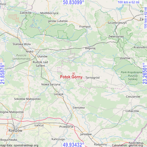
Potok Górny GPS coordinates[2]
50° 23' 5.172" North, 22° 33' 42.768" East
| Map corner | latitude | longitude |
|---|---|---|
| Upper-left | 50.83099°, | 21.85876° |
| Center: | 50.38477°, | 22.56188° |
| Lower-right: | 49.93432°, | 23.26501° |
| Map W x H: | 99.7×99.7 km | = 62×62mi |
| max Lat: | 54.83135° ⇑69.8% North |
| Potok Górny: | 50.38477° |
| min Lat: | ⇓30.2% South 49.21328° |
| min Long | Potok Górny | max Long |
| 14.20249° | 22.56188° | 24.03723° |
| W 92.4%⇐ | ⇒7.6% E |
Elevation
Elevation of Potok Górny is 211 m = 692 ft, and this is 19.6 m = 64 ft above average elevation for this country.
| Max E: |
974 m = 3196 ft | 36.2% |
| Potok Górny | 211 m 692 ft | |
| Avg. | 191.4 m = 628 ft | |
Min E: |
-3 m = -10 ft | 63.8% |
See also: Poland elevation on elevation.city.
Geographical zone
Potok Górny is located in North temperate zone (between Tropic of Cancer and the Arctic Circle). Distance of this North polar circle is 1798.9 km =1117.8 mi to North.| Distance of | km | miles | from Potok Górny |
|---|---|---|---|
| North Pole | 4404.8 | 2737 | to North |
| Arctic Circle | 1798.9 | 1117.8 | to North |
| Tropic Cancer | 2996.3 | 1861.8 | to South |
| Equator | 5602.3 | 3481.1 | to South |


Nearby cities:
15 places around Potok Górny: (largest is in red/bold)
• Adamówka
17 km =10.6 mi,  145°
145°
• Biszcza
6.6 km =4.1 mi,  73°
73°
• Bystre
11.8 km =7.3 mi,  266°
266°
• Harasiuki
11.9 km =7.4 mi,  327°
327°
• Krzeszów
15.7 km =9.8 mi,  277°
277°
• Księżpol
13 km =8.1 mi, 70°
• Kuryłówka
11.6 km =7.2 mi,  215°
215°
• Leżajsk
16.9 km =10.5 mi, 216°
• Nowa Sarzyna
17 km =10.6 mi,  245°
245°
• Piskorowice
16.7 km =10.4 mi,  188°
188°
• Przychojec
14.9 km =9.3 mi,  229°
229°
• Stare Miasto
14.2 km =8.8 mi, 221°
• Tarnogród
13 km =8.1 mi,  101°
101°
• Tarnogóra
17.4 km =10.8 mi,  264°
264°
• Łukowa
15.1 km =9.4 mi,  244°
244°
Sources, notices
• [Note1] Compared only with cities in Poland existing in our database
• [Src1] Map data: © OpenStreetMap contributors (CC-BY-SA)
• [Src2] Other city data from geonames.org with taken over terms of usage.
• [Src3] Geographical zone / Annual Mean Temperature by Robert A. Rohde @ Wikipedia
