Culebra geodata
Culebra is a seat of a first-order administrative division; located in Puerto Rico in America/Puerto_Rico (GMT-4) time zone. With population of 1,486 people, there are 175 cities with bigger population in this country. Compared to other cities in Puerto Rico, 58.7% of cities are located further ↓South; 100% of cities are located further ←West and 92.9% of cities have higher elevation than Culebra. Note1


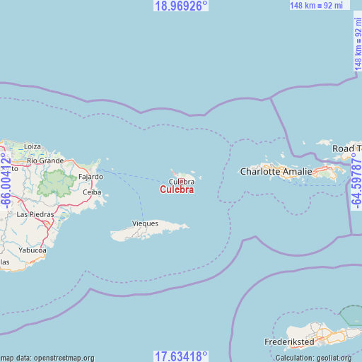
Culebra GPS coordinates[2]
18° 18' 10.836" North, 65° 18' 3.564" West
| Map corner | latitude | longitude |
|---|---|---|
| Upper-left | 18.96926°, | -66.00412° |
| Center: | 18.30301°, | -65.30099° |
| Lower-right: | 17.63418°, | -64.59787° |
| Map W x H: | 148.4×148.4 km | = 92.2×92.2mi |
| max Lat: | 18.50078° ⇑41.3% North |
| Culebra: | 18.30301° |
| min Lat: | ⇓58.7% South 17.95358° |
| min Long | Culebra | max Long |
| -67.2499° | -65.30099° | -65.30099° |
| W 100%⇐ | ⇒0% E |
Elevation
Elevation of Culebra is 7 m = 23 ft, and this is 93.5 m = 307 ft below average elevation for this country.
| Max E: |
655 m = 2149 ft | 92.9% |
| Avg. | 100.5 m = 330 ft | |
| Culebra | 7 m = 23 ft | |
Min E: |
1 m = 3 ft | 7.1% |
See also: Puerto Rico elevation on elevation.city.
Geographical zone
Culebra is located in North Torrid zone (between Equator and Tropic of Cancer). Distance of this Northern Tropic circle is 570.8 km =354.7 mi to North.| Distance of | km | miles | from Culebra |
|---|---|---|---|
| North Pole | 7972 | 4953.6 | to North |
| Arctic Circle | 5366.1 | 3334.3 | to North |
| Tropic Cancer | 570.8 | 354.7 | to North |
| Equator | 2035.1 | 1264.6 | to South |


Nearby cities:
15 places around Culebra: (largest is in red/bold)
• Aguas Claras
37.6 km =23.4 mi,  261°
261°
• Ceiba
36.9 km =22.9 mi, 263°
• Daguao
41.2 km =25.6 mi, 258°
• Duque
47.1 km =29.3 mi, 260°
• Esperanza
29.1 km =18.1 mi,  218°
218°
• Fajardo
37.2 km =23.1 mi,  273°
273°
• Hato Candal
51.9 km =32.2 mi,  278°
278°
• Isabel Segunda
22.7 km =14.1 mi, 221°
• Luis M. Cintron
35.6 km =22.1 mi, 269°
• Luquillo
44.5 km =27.7 mi, 279°
• Naguabo
46.9 km =29.1 mi, 257°
• Palmer
50.5 km =31.4 mi, 278°
• Playa Fortuna
47.6 km =29.6 mi, 280°
• Punta Santiago
49.6 km =30.8 mi,  252°
252°
• Ramos
43.6 km =27.1 mi, 275°
Sources, notices
• [Note1] Compared only with cities in Puerto Rico existing in our database
• [Src1] Map data: © OpenStreetMap contributors (CC-BY-SA)
• [Src2] Other city data from geonames.org with taken over terms of usage.
• [Src3] Geographical zone / Annual Mean Temperature by Robert A. Rohde @ Wikipedia
