Yabucoa geodata
Yabucoa is a seat of a first-order administrative division; located in Puerto Rico in America/Puerto_Rico (GMT-4) time zone. With population of 6,952 people, there are 48 cities with bigger population in this country. Compared to other cities in Puerto Rico, 76.9% of cities are located further ↑North; 84.9% of cities are located further ←West and 65.3% of cities have higher elevation than Yabucoa. Note1


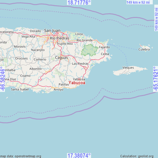
Yabucoa GPS coordinates[2]
18° 3' 1.872" North, 65° 52' 45.588" West
| Map corner | latitude | longitude |
|---|---|---|
| Upper-left | 18.71776°, | -66.58246° |
| Center: | 18.05052°, | -65.87933° |
| Lower-right: | 17.38074°, | -65.17621° |
| Map W x H: | 148.7×148.7 km | = 92.4×92.4mi |
| max Lat: | 18.50078° ⇑76.9% North |
| Yabucoa: | 18.05052° |
| min Lat: | ⇓23.1% South 17.95358° |
| min Long | Yabucoa | max Long |
| -67.2499° | -65.87933° | -65.30099° |
| W 84.9%⇐ | ⇒15.1% E |
Elevation
Elevation of Yabucoa is 27 m = 89 ft, and this is 73.5 m = 241 ft below average elevation for this country.
| Max E: |
655 m = 2149 ft | 65.3% |
| Avg. | 100.5 m = 330 ft | |
| Yabucoa | 27 m = 89 ft | |
Min E: |
1 m = 3 ft | 34.7% |
See also: Puerto Rico elevation on elevation.city.
Geographical zone
Yabucoa is located in North Torrid zone (between Equator and Tropic of Cancer). Distance of this Northern Tropic circle is 598.9 km =372.1 mi to North.| Distance of | km | miles | from Yabucoa |
|---|---|---|---|
| North Pole | 8000 | 4971 | to North |
| Arctic Circle | 5394.1 | 3351.7 | to North |
| Tropic Cancer | 598.9 | 372.1 | to North |
| Equator | 2007 | 1247.1 | to South |


Nearby cities:
15 places around Yabucoa: (largest is in red/bold)
• Bajandas
15.8 km =9.8 mi,  40°
40°
• Candelero Arriba
7.3 km =4.5 mi, 38°
• Comunas
5.5 km =3.4 mi, 42°
• El Negro
3.3 km =2.1 mi,  116°
116°
• Emajagua
5.6 km =3.5 mi,  183°
183°
• Humacao
12.3 km =7.6 mi,  26°
26°
• La Fermina
14.2 km =8.8 mi,  11°
11°
• Lamboglia
13.6 km =8.5 mi,  235°
235°
• Las Piedras
14.8 km =9.2 mi, 5°
• Martorell
3.5 km =2.2 mi,  324°
324°
• Maunabo
5.3 km =3.3 mi,  203°
203°
• Palo Seco
7.7 km =4.8 mi,  231°
231°
• Patillas
15.2 km =9.4 mi,  251°
251°
• Playita
3 km =1.9 mi,  257°
257°
• Rosa Sanchez
3.8 km =2.4 mi,  288°
288°
Sources, notices
• [Note1] Compared only with cities in Puerto Rico existing in our database
• [Src1] Map data: © OpenStreetMap contributors (CC-BY-SA)
• [Src2] Other city data from geonames.org with taken over terms of usage.
• [Src3] Geographical zone / Annual Mean Temperature by Robert A. Rohde @ Wikipedia
