Vila Viçosa geodata
Vila Viçosa (Évora) is a seat of a second-order administrative division; located in Portugal in Europe/Lisbon (GMT+1) time zone. With population of 8,319 people, there are 270 cities with bigger population in this country. Compared to other cities in Portugal, 70.4% of cities are located further ↑North; 94.6% of cities are located further ←West and 87.6% of cities have lower elevation than Vila Viçosa. Note1
Administrative division(s):
- Level 1: Évora
- Level 2: Vila Viçosa
- Level 3: Vila Viçosa (São Bartolomeu)


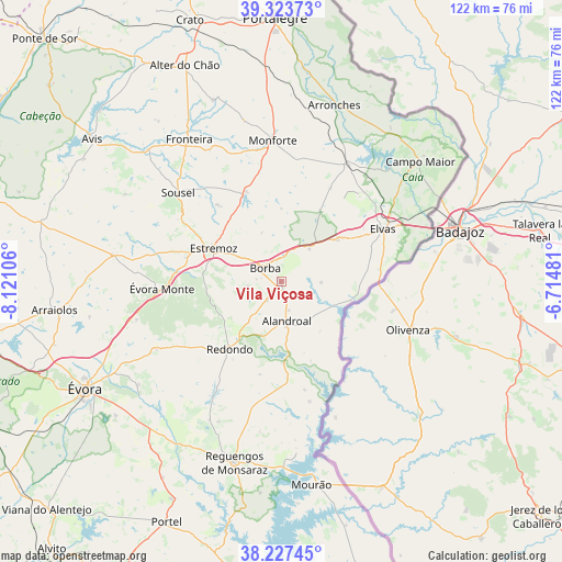
Vila Viçosa GPS coordinates[2]
38° 46' 39.72" North, 7° 25' 4.548" West
| Map corner | latitude | longitude |
|---|---|---|
| Upper-left | 39.32373°, | -8.12106° |
| Center: | 38.7777°, | -7.41793° |
| Lower-right: | 38.22745°, | -6.71481° |
| Map W x H: | 121.9×121.9 km | = 75.7×75.7mi |
| max Lat: | 42.11337° ⇑70.4% North |
| Vila Viçosa: | 38.7777° |
| min Lat: | ⇓29.6% South 32.6448° |
| min Long | Vila Viçosa | max Long |
| -31.17847° | -7.41793° | -6.27308° |
| W 94.6%⇐ | ⇒5.4% E |
Elevation
Elevation of Vila Viçosa is 403 m = 1322 ft, and this is 226 m = 741 ft above average elevation for this country.
| Max E: |
1008 m = 3307 ft | 12.4% |
| Vila Viçosa | 403 m 1322 ft | |
| Avg. | 177 m = 581 ft | |
Min E: |
-128 m = -420 ft | 87.6% |
See also: Portugal elevation on elevation.city.
Geographical zone
Vila Viçosa is located in North temperate zone (between Tropic of Cancer and the Arctic Circle). Distance of this Northern Tropic circle is 1705.8 km =1059.9 mi to South.| Distance of | km | miles | from Vila Viçosa |
|---|---|---|---|
| North Pole | 5695.4 | 3539 | to North |
| Arctic Circle | 3089.5 | 1919.7 | to North |
| Tropic Cancer | 1705.8 | 1059.9 | to South |
| Equator | 4311.7 | 2679.2 | to South |


Nearby cities:
15 places around Vila Viçosa: (largest is in red/bold)
• Alandroal
8.5 km =5.3 mi,  171°
171°
• Arraiolos
49.5 km =30.8 mi,  263°
263°
• Arronches
40 km =24.9 mi,  16°
16°
• Borba
4.4 km =2.7 mi,  314°
314°
• Campo Maior
40.6 km =25.2 mi,  48°
48°
• Elvas
24.9 km =15.5 mi,  62°
62°
• Estremoz
16.3 km =10.1 mi,  296°
296°
• Fronteira
36.9 km =22.9 mi,  327°
327°
• Monforte
30.7 km =19.1 mi,  356°
356°
• Mourão
44.3 km =27.5 mi, 171°
• Redondo
18.2 km =11.3 mi,  218°
218°
• Reguengos de Monsaraz
40.5 km =25.2 mi,  194°
194°
• Urra
50.1 km =31.1 mi,  1°
1°
• Vale da Amoreira
40.5 km =25.2 mi,  323°
323°
• Évora
48 km =29.8 mi,  240°
240°
Sources, notices
• [Note1] Compared only with cities in Portugal existing in our database
• [Src1] Map data: © OpenStreetMap contributors (CC-BY-SA)
• [Src2] Other city data from geonames.org with taken over terms of usage.
• [Src3] Geographical zone / Annual Mean Temperature by Robert A. Rohde @ Wikipedia
