Borba geodata
Borba (Évora) is a seat of a second-order administrative division; located in Portugal in Europe/Lisbon (GMT+1) time zone. With population of 4,586 people, there are 462 cities with bigger population in this country. Compared to other cities in Portugal, 68.6% of cities are located further ↑North; 93.8% of cities are located further ←West and 87.6% of cities have lower elevation than Borba. Note1


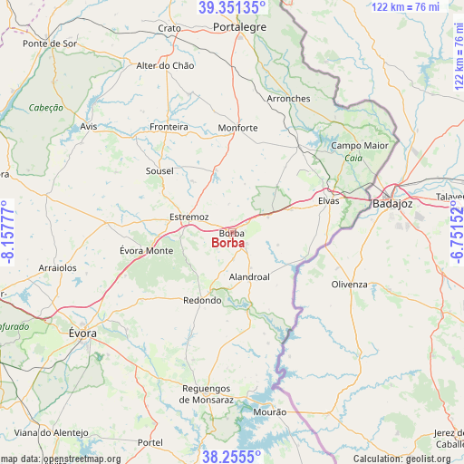
Borba GPS coordinates[2]
38° 48' 19.908" North, 7° 27' 16.74" West
| Map corner | latitude | longitude |
|---|---|---|
| Upper-left | 39.35135°, | -8.15777° |
| Center: | 38.80553°, | -7.45465° |
| Lower-right: | 38.2555°, | -6.75152° |
| Map W x H: | 121.8×121.8 km | = 75.7×75.7mi |
| max Lat: | 42.11337° ⇑68.6% North |
| Borba: | 38.80553° |
| min Lat: | ⇓31.4% South 32.6448° |
| min Long | Borba | max Long |
| -31.17847° | -7.45465° | -6.27308° |
| W 93.8%⇐ | ⇒6.2% E |
Elevation
Elevation of Borba is 403 m = 1322 ft, and this is 226 m = 741 ft above average elevation for this country.
| Max E: |
1008 m = 3307 ft | 12.4% |
| Borba | 403 m 1322 ft | |
| Avg. | 177 m = 581 ft | |
Min E: |
-128 m = -420 ft | 87.6% |
See also: Portugal elevation on elevation.city.
Geographical zone
Borba is located in North temperate zone (between Tropic of Cancer and the Arctic Circle). Distance of this Northern Tropic circle is 1708.9 km =1061.9 mi to South.| Distance of | km | miles | from Borba |
|---|---|---|---|
| North Pole | 5692.3 | 3537 | to North |
| Arctic Circle | 3086.4 | 1917.8 | to North |
| Tropic Cancer | 1708.9 | 1061.9 | to South |
| Equator | 4314.8 | 2681.1 | to South |


Nearby cities:
15 places around Borba: (largest is in red/bold)
• Alandroal
12.3 km =7.6 mi,  158°
158°
• Alter do Chão
47 km =29.2 mi,  337°
337°
• Arraiolos
46.9 km =29.1 mi,  258°
258°
• Arronches
38.1 km =23.7 mi,  22°
22°
• Avis
46.8 km =29.1 mi,  306°
306°
• Campo Maior
41.2 km =25.6 mi,  55°
55°
• Elvas
26.6 km =16.5 mi,  71°
71°
• Estremoz
12.2 km =7.6 mi,  290°
290°
• Fronteira
32.5 km =20.2 mi,  328°
328°
• Monforte
27.6 km =17.1 mi,  3°
3°
• Redondo
19.2 km =11.9 mi,  204°
204°
• Reguengos de Monsaraz
42.9 km =26.7 mi,  189°
189°
• Vale da Amoreira
36.2 km =22.5 mi,  324°
324°
• Vila Viçosa
4.4 km =2.7 mi,  134°
134°
• Évora
46.9 km =29.1 mi,  235°
235°
Sources, notices
• [Note1] Compared only with cities in Portugal existing in our database
• [Src1] Map data: © OpenStreetMap contributors (CC-BY-SA)
• [Src2] Other city data from geonames.org with taken over terms of usage.
• [Src3] Geographical zone / Annual Mean Temperature by Robert A. Rohde @ Wikipedia
