Estremoz geodata
Estremoz (Évora) is a seat of a second-order administrative division; located in Portugal in Europe/Lisbon (GMT+0) time zone. With population of 9,350 people, there are 235 cities with bigger population in this country. Compared to other cities in Portugal, 67.4% of cities are located further ↑North; 90% of cities are located further ←West and 88.2% of cities have lower elevation than Estremoz. Note1


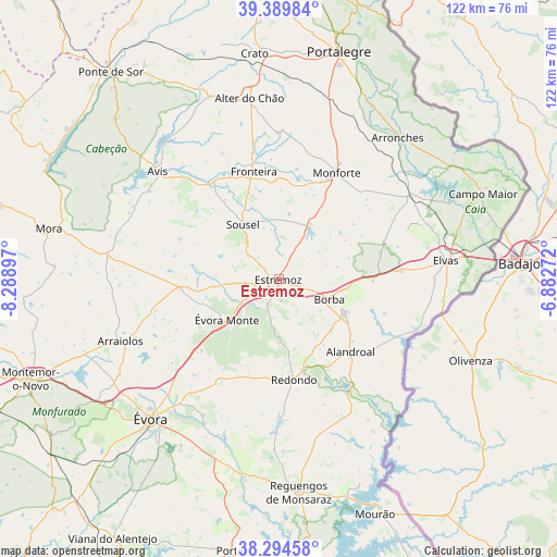
Estremoz GPS coordinates[2]
38° 50' 39.552" North, 7° 35' 9.06" West
| Map corner | latitude | longitude |
|---|---|---|
| Upper-left | 39.38984°, | -8.28897° |
| Center: | 38.84432°, | -7.58585° |
| Lower-right: | 38.29458°, | -6.88272° |
| Map W x H: | 121.8×121.8 km | = 75.7×75.7mi |
| max Lat: | 42.11337° ⇑67.4% North |
| Estremoz: | 38.84432° |
| min Lat: | ⇓32.6% South 32.6448° |
| min Long | Estremoz | max Long |
| -31.17847° | -7.58585° | -6.27308° |
| W 90%⇐ | ⇒10% E |
Elevation
Elevation of Estremoz is 417 m = 1368 ft, and this is 240 m = 787 ft above average elevation for this country.
| Max E: |
1008 m = 3307 ft | 11.8% |
| Estremoz | 417 m 1368 ft | |
| Avg. | 177 m = 581 ft | |
Min E: |
-128 m = -420 ft | 88.2% |
See also: Portugal elevation on elevation.city.
Geographical zone
Estremoz is located in North temperate zone (between Tropic of Cancer and the Arctic Circle). Distance of this Northern Tropic circle is 1713.2 km =1064.5 mi to South.| Distance of | km | miles | from Estremoz |
|---|---|---|---|
| North Pole | 5688 | 3534.4 | to North |
| Arctic Circle | 3082.1 | 1915.1 | to North |
| Tropic Cancer | 1713.2 | 1064.5 | to South |
| Equator | 4319.1 | 2683.8 | to South |


Nearby cities:
15 places around Estremoz: (largest is in red/bold)
• Alandroal
22.4 km =13.9 mi,  134°
134°
• Alter do Chão
39.8 km =24.7 mi,  350°
350°
• Arraiolos
37.1 km =23.1 mi,  248°
248°
• Arronches
40.3 km =25 mi,  39°
39°
• Avis
35.2 km =21.9 mi,  311°
311°
• Borba
12.2 km =7.6 mi,  110°
110°
• Elvas
36.9 km =22.9 mi,  83°
83°
• Fronteira
24.2 km =15 mi, 347°
• Monforte
26.6 km =16.5 mi,  29°
29°
• Redondo
22 km =13.7 mi,  171°
171°
• Reguengos de Monsaraz
46.8 km =29.1 mi, 174°
• Urra
45.7 km =28.4 mi,  20°
20°
• Vale da Amoreira
26.9 km =16.7 mi,  338°
338°
• Vila Viçosa
16.3 km =10.1 mi,  116°
116°
• Évora
41.2 km =25.6 mi,  221°
221°
Sources, notices
• [Note1] Compared only with cities in Portugal existing in our database
• [Src1] Map data: © OpenStreetMap contributors (CC-BY-SA)
• [Src2] Other city data from geonames.org with taken over terms of usage.
• [Src3] Geographical zone / Annual Mean Temperature by Robert A. Rohde @ Wikipedia
