Alandroal geodata
Alandroal (Évora) is a seat of a second-order administrative division; located in Portugal in Europe/Lisbon (GMT+1) time zone. In our database, there are 824 cities with bigger population. Compared to other cities in Portugal, 74.2% of cities are located further ↑North; 95% of cities are located further ←West and 84.3% of cities have lower elevation than Alandroal. Note1
Administrative division(s):
- Level 1: Évora
- Level 2: Alandroal
- Level 3: Alandroal (Nossa Senhora da Conceição)


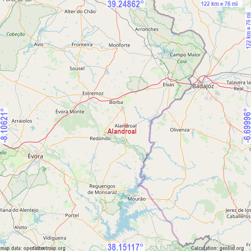
Alandroal GPS coordinates[2]
38° 42' 7.2" North, 7° 24' 11.124" West
| Map corner | latitude | longitude |
|---|---|---|
| Upper-left | 39.24862°, | -8.10621° |
| Center: | 38.702°, | -7.40309° |
| Lower-right: | 38.15117°, | -6.69996° |
| Map W x H: | 122×122 km | = 75.8×75.8mi |
| max Lat: | 42.11337° ⇑74.2% North |
| Alandroal: | 38.702° |
| min Lat: | ⇓25.8% South 32.6448° |
| min Long | Alandroal | max Long |
| -31.17847° | -7.40309° | -6.27308° |
| W 95%⇐ | ⇒5% E |
Elevation
Elevation of Alandroal is 345 m = 1132 ft, and this is 168 m = 551 ft above average elevation for this country.
| Max E: |
1008 m = 3307 ft | 15.7% |
| Alandroal | 345 m 1132 ft | |
| Avg. | 177 m = 581 ft | |
Min E: |
-128 m = -420 ft | 84.3% |
See also: Portugal elevation on elevation.city.
Geographical zone
Alandroal is located in North temperate zone (between Tropic of Cancer and the Arctic Circle). Distance of this Northern Tropic circle is 1697.3 km =1054.7 mi to South.| Distance of | km | miles | from Alandroal |
|---|---|---|---|
| North Pole | 5703.8 | 3544.2 | to North |
| Arctic Circle | 3097.9 | 1924.9 | to North |
| Tropic Cancer | 1697.3 | 1054.7 | to South |
| Equator | 4303.3 | 2673.9 | to South |


Nearby cities:
15 places around Alandroal: (largest is in red/bold)
• Arraiolos
50.5 km =31.4 mi,  272°
272°
• Arronches
47.8 km =29.7 mi,  12°
12°
• Borba
12.3 km =7.6 mi,  338°
338°
• Campo Maior
45.7 km =28.4 mi,  39°
39°
• Elvas
28.8 km =17.9 mi,  46°
46°
• Estremoz
22.4 km =13.9 mi,  314°
314°
• Fronteira
44.8 km =27.8 mi,  331°
331°
• Monforte
39.2 km =24.4 mi,  355°
355°
• Mourão
35.8 km =22.2 mi,  171°
171°
• Portel
51.1 km =31.8 mi,  210°
210°
• Redondo
13.8 km =8.6 mi,  244°
244°
• Reguengos de Monsaraz
32.8 km =20.4 mi,  200°
200°
• Vale da Amoreira
48.2 km =30 mi, 327°
• Vila Viçosa
8.5 km =5.3 mi,  351°
351°
• Évora
45.7 km =28.4 mi,  250°
250°
Sources, notices
• [Note1] Compared only with cities in Portugal existing in our database
• [Src1] Map data: © OpenStreetMap contributors (CC-BY-SA)
• [Src2] Other city data from geonames.org with taken over terms of usage.
• [Src3] Geographical zone / Annual Mean Temperature by Robert A. Rohde @ Wikipedia
