Redondo geodata
Redondo (Évora) is a seat of a second-order administrative division; located in Portugal in Europe/Lisbon (GMT+1) time zone. With population of 5,845 people, there are 372 cities with bigger population in this country. Compared to other cities in Portugal, 77.9% of cities are located further ↑North; 90.5% of cities are located further ←West and 81.2% of cities have lower elevation than Redondo. Note1


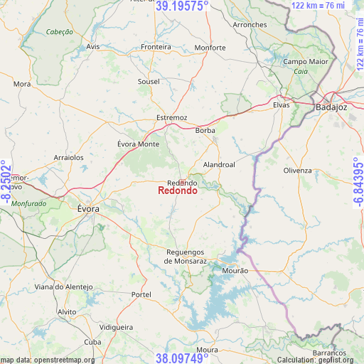
Redondo GPS coordinates[2]
38° 38' 55.392" North, 7° 32' 49.488" West
| Map corner | latitude | longitude |
|---|---|---|
| Upper-left | 39.19575°, | -8.2502° |
| Center: | 38.64872°, | -7.54708° |
| Lower-right: | 38.09749°, | -6.84395° |
| Map W x H: | 122.1×122.1 km | = 75.9×75.9mi |
| max Lat: | 42.11337° ⇑77.9% North |
| Redondo: | 38.64872° |
| min Lat: | ⇓22.1% South 32.6448° |
| min Long | Redondo | max Long |
| -31.17847° | -7.54708° | -6.27308° |
| W 90.5%⇐ | ⇒9.5% E |
Elevation
Elevation of Redondo is 298 m = 978 ft, and this is 121 m = 397 ft above average elevation for this country.
| Max E: |
1008 m = 3307 ft | 18.8% |
| Redondo | 298 m 978 ft | |
| Avg. | 177 m = 581 ft | |
Min E: |
-128 m = -420 ft | 81.2% |
See also: Portugal elevation on elevation.city.
Geographical zone
Redondo is located in North temperate zone (between Tropic of Cancer and the Arctic Circle). Distance of this Northern Tropic circle is 1691.4 km =1051 mi to South.| Distance of | km | miles | from Redondo |
|---|---|---|---|
| North Pole | 5709.7 | 3547.8 | to North |
| Arctic Circle | 3103.8 | 1928.6 | to North |
| Tropic Cancer | 1691.4 | 1051 | to South |
| Equator | 4297.3 | 2670.2 | to South |


Nearby cities:
15 places around Redondo: (largest is in red/bold)
• Alandroal
13.8 km =8.6 mi,  64°
64°
• Arraiolos
38.9 km =24.2 mi,  282°
282°
• Borba
19.2 km =11.9 mi,  24°
24°
• Elvas
42.2 km =26.2 mi,  52°
52°
• Estremoz
22 km =13.7 mi,  351°
351°
• Fronteira
46.2 km =28.7 mi, 349°
• Monforte
46 km =28.6 mi,  11°
11°
• Mourão
34.5 km =21.4 mi,  148°
148°
• Portel
40.3 km =25 mi,  199°
199°
• Reguengos de Monsaraz
24.9 km =15.5 mi,  177°
177°
• Vale da Amoreira
48.6 km =30.2 mi,  344°
344°
• Viana do Alentejo
53 km =32.9 mi,  228°
228°
• Vidigueira
53.5 km =33.2 mi, 204°
• Vila Viçosa
18.2 km =11.3 mi,  38°
38°
• Évora
32 km =19.9 mi,  253°
253°
Sources, notices
• [Note1] Compared only with cities in Portugal existing in our database
• [Src1] Map data: © OpenStreetMap contributors (CC-BY-SA)
• [Src2] Other city data from geonames.org with taken over terms of usage.
• [Src3] Geographical zone / Annual Mean Temperature by Robert A. Rohde @ Wikipedia
