Oleiros geodata
Oleiros (Castelo Branco) is a seat of a second-order administrative division; located in Portugal in Europe/Lisbon (GMT+1) time zone. With population of 5,721 people, there are 380 cities with bigger population in this country. Compared to other cities in Portugal, 52.9% of cities are located further ↓South; 82% of cities are located further ←West and 91.6% of cities have lower elevation than Oleiros. Note1


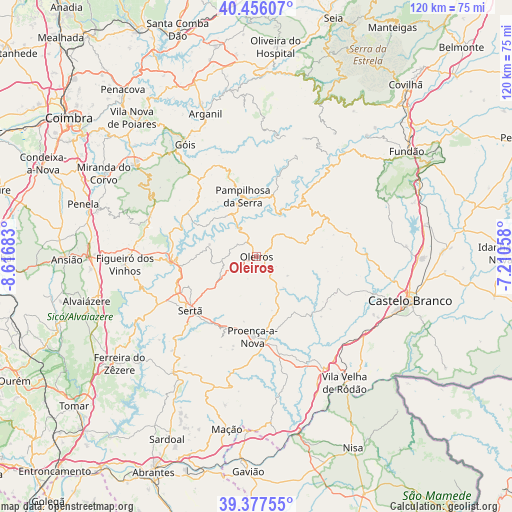
Oleiros GPS coordinates[2]
39° 55' 8.148" North, 7° 54' 49.32" West
| Map corner | latitude | longitude |
|---|---|---|
| Upper-left | 40.45607°, | -8.61683° |
| Center: | 39.91893°, | -7.9137° |
| Lower-right: | 39.37755°, | -7.21058° |
| Map W x H: | 119.9×119.9 km | = 74.5×74.5mi |
| max Lat: | 42.11337° ⇑47.1% North |
| Oleiros: | 39.91893° |
| min Lat: | ⇓52.9% South 32.6448° |
| min Long | Oleiros | max Long |
| -31.17847° | -7.9137° | -6.27308° |
| W 82%⇐ | ⇒18% E |
Elevation
Elevation of Oleiros is 510 m = 1673 ft, and this is 333 m = 1093 ft above average elevation for this country.
| Max E: |
1008 m = 3307 ft | 8.4% |
| Oleiros | 510 m 1673 ft | |
| Avg. | 177 m = 581 ft | |
Min E: |
-128 m = -420 ft | 91.6% |
See also: Portugal elevation on elevation.city.
Geographical zone
Oleiros is located in North temperate zone (between Tropic of Cancer and the Arctic Circle). Distance of this Northern Tropic circle is 1832.6 km =1138.7 mi to South.| Distance of | km | miles | from Oleiros |
|---|---|---|---|
| North Pole | 5568.5 | 3460.1 | to North |
| Arctic Circle | 2962.6 | 1840.9 | to North |
| Tropic Cancer | 1832.6 | 1138.7 | to South |
| Equator | 4438.6 | 2758 | to South |


Nearby cities:
15 places around Oleiros: (largest is in red/bold)
• Arganil
35.4 km =22 mi,  340°
340°
• Barroca Grande
29.7 km =18.5 mi,  28°
28°
• Carvoeiro
32.7 km =20.3 mi,  181°
181°
• Castanheira de Pêra
27.1 km =16.8 mi,  291°
291°
• Figueiró dos Vinhos
30.9 km =19.2 mi,  266°
266°
• Góis
31.3 km =19.4 mi,  327°
327°
• Pampilhosa da Serra
14.5 km =9 mi,  347°
347°
• Pedrógão Grande
19.8 km =12.3 mi, 269°
• Proença-a-Nova
18.6 km =11.6 mi, 182°
• Sertã
20.3 km =12.6 mi,  230°
230°
• São Jorge da Beira
30.7 km =19.1 mi,  24°
24°
• Unhais-o-Velho
25.2 km =15.7 mi, 20°
• Vila Nova de Ceira
35.5 km =22.1 mi, 325°
• Vila Velha de Ródão
35.5 km =22.1 mi,  145°
145°
• Vila de Rei
33.5 km =20.8 mi,  216°
216°
Sources, notices
• [Note1] Compared only with cities in Portugal existing in our database
• [Src1] Map data: © OpenStreetMap contributors (CC-BY-SA)
• [Src2] Other city data from geonames.org with taken over terms of usage.
• [Src3] Geographical zone / Annual Mean Temperature by Robert A. Rohde @ Wikipedia
