Pampilhosa da Serra geodata
Pampilhosa da Serra (Coimbra) is a seat of a second-order administrative division; located in Portugal in Europe/Lisbon (GMT+1) time zone. With population of 1,389 people, there are 701 cities with bigger population in this country. Compared to other cities in Portugal, 53.6% of cities are located further ↓South; 80.7% of cities are located further ←West and 87.1% of cities have lower elevation than Pampilhosa da Serra. Note1
Administrative division(s):
- Level 1: Coimbra
- Level 2: Pampilhosa da Serra
- Level 3: Pampilhosa da Serra


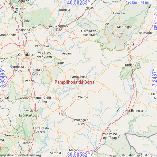
Pampilhosa da Serra GPS coordinates[2]
40° 2' 46.32" North, 7° 57' 6.552" West
| Map corner | latitude | longitude |
|---|---|---|
| Upper-left | 40.58233°, | -8.65495° |
| Center: | 40.0462°, | -7.95182° |
| Lower-right: | 39.50582°, | -7.2487° |
| Map W x H: | 119.7×119.7 km | = 74.4×74.4mi |
| max Lat: | 42.11337° ⇑46.4% North |
| Pampilhosa da Serra: | 40.0462° |
| min Lat: | ⇓53.6% South 32.6448° |
| min Long | Pampilhosa da S | max Long |
| -31.17847° | -7.95182° | -6.27308° |
| W 80.7%⇐ | ⇒19.3% E |
Elevation
Elevation of Pampilhosa da Serra is 398 m = 1306 ft, and this is 221 m = 725 ft above average elevation for this country.
| Max E: |
1008 m = 3307 ft | 12.9% |
| Pampilhosa da Serra | 398 m 1306 ft | |
| Avg. | 177 m = 581 ft | |
Min E: |
-128 m = -420 ft | 87.1% |
See also: Portugal elevation on elevation.city.
Geographical zone
Pampilhosa da Serra is located in North temperate zone (between Tropic of Cancer and the Arctic Circle). Distance of this Northern Tropic circle is 1846.8 km =1147.5 mi to South.| Distance of | km | miles | from Pampilhosa da Serra |
|---|---|---|---|
| North Pole | 5554.3 | 3451.3 | to North |
| Arctic Circle | 2948.5 | 1832.1 | to North |
| Tropic Cancer | 1846.8 | 1147.5 | to South |
| Equator | 4452.7 | 2766.8 | to South |


Nearby cities:
15 places around Pampilhosa da Serra: (largest is in red/bold)
• Arganil
21 km =13 mi,  335°
335°
• Avô
27.7 km =17.2 mi,  8°
8°
• Barroca Grande
21 km =13 mi,  55°
55°
• Castanheira de Pêra
22.4 km =13.9 mi,  258°
258°
• Góis
18.3 km =11.4 mi,  312°
312°
• Lousã
26.5 km =16.5 mi,  287°
287°
• Oleiros
14.5 km =9 mi,  167°
167°
• Pedrógão Grande
21.8 km =13.5 mi,  229°
229°
• Poiares
31.7 km =19.7 mi, 305°
• Santa Ovaia
30.3 km =18.8 mi, 10°
• Sertã
29.8 km =18.5 mi,  204°
204°
• São Jorge da Beira
21.1 km =13.1 mi,  49°
49°
• Unhais-o-Velho
15.3 km =9.5 mi, 51°
• Vide
31.1 km =19.3 mi,  27°
27°
• Vila Nova de Ceira
22.7 km =14.1 mi, 311°
Sources, notices
• [Note1] Compared only with cities in Portugal existing in our database
• [Src1] Map data: © OpenStreetMap contributors (CC-BY-SA)
• [Src2] Other city data from geonames.org with taken over terms of usage.
• [Src3] Geographical zone / Annual Mean Temperature by Robert A. Rohde @ Wikipedia
