Santiago do Cacém geodata
Santiago do Cacém (District of Setúbal) is a seat of a second-order administrative division; located in Portugal in Europe/Lisbon (GMT+0) time zone. With population of 7,797 people, there are 292 cities with bigger population in this country. Compared to other cities in Portugal, 83.9% of cities are located further ↑North; 62.7% of cities are located further →East and 73.1% of cities have lower elevation than Santiago do Cacém. Note1
Administrative division(s):
- Level 1: District of Setúbal
- Level 2: Santiago do Cacém
- Level 3: Santiago do Cacém


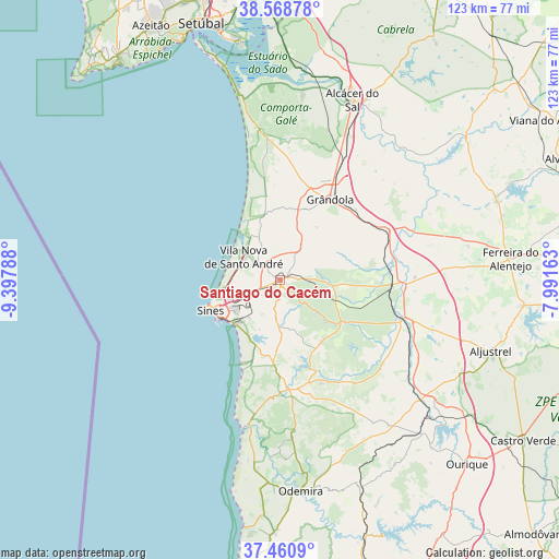
Santiago do Cacém GPS coordinates[2]
38° 1' 0.948" North, 8° 41' 41.1" West
| Map corner | latitude | longitude |
|---|---|---|
| Upper-left | 38.56878°, | -9.39788° |
| Center: | 38.01693°, | -8.69475° |
| Lower-right: | 37.4609°, | -7.99163° |
| Map W x H: | 123.2×123.2 km | = 76.6×76.6mi |
| max Lat: | 42.11337° ⇑83.9% North |
| Santiago do Cacém: | 38.01693° |
| min Lat: | ⇓16.1% South 32.6448° |
| min Long | Santiago do Cac | max Long |
| -31.17847° | -8.69475° | -6.27308° |
| W 37.3%⇐ | ⇒62.7% E |
Elevation
Elevation of Santiago do Cacém is 220 m = 722 ft, and this is 43 m = 141 ft above average elevation for this country.
| Max E: |
1008 m = 3307 ft | 26.9% |
| Santiago do Cacém | 220 m 722 ft | |
| Avg. | 177 m = 581 ft | |
Min E: |
-128 m = -420 ft | 73.1% |
See also: Portugal elevation on elevation.city.
Geographical zone
Santiago do Cacém is located in North temperate zone (between Tropic of Cancer and the Arctic Circle). Distance of this Northern Tropic circle is 1621.2 km =1007.4 mi to South.| Distance of | km | miles | from Santiago do Cacém |
|---|---|---|---|
| North Pole | 5780 | 3591.5 | to North |
| Arctic Circle | 3174.1 | 1972.3 | to North |
| Tropic Cancer | 1621.2 | 1007.4 | to South |
| Equator | 4227.1 | 2626.6 | to South |


Nearby cities:
15 places around Santiago do Cacém: (largest is in red/bold)
• Alcácer do Sal
42.6 km =26.5 mi,  21°
21°
• Aljustrel
49 km =30.4 mi,  108°
108°
• Almograve
41 km =25.5 mi,  192°
192°
• Boavista dos Pinheiros
48.6 km =30.2 mi,  176°
176°
• Cercal
24 km =14.9 mi, 175°
• Comporta
41.2 km =25.6 mi,  348°
348°
• Grândola
21 km =13 mi,  32°
32°
• Odemira
46.8 km =29.1 mi,  174°
174°
• Porto Covo
20.1 km =12.5 mi,  204°
204°
• Santo André
9.1 km =5.7 mi,  302°
302°
• Sines
16.8 km =10.4 mi,  246°
246°
• São Luis
33.6 km =20.9 mi, 175°
• São Teotónio
56.1 km =34.9 mi, 181°
• Vila Nova de Milfontes
33.5 km =20.8 mi, 193°
• Zambujeira do Mar
54.9 km =34.1 mi, 188°
Sources, notices
• [Note1] Compared only with cities in Portugal existing in our database
• [Src1] Map data: © OpenStreetMap contributors (CC-BY-SA)
• [Src2] Other city data from geonames.org with taken over terms of usage.
• [Src3] Geographical zone / Annual Mean Temperature by Robert A. Rohde @ Wikipedia
