Montemor-o-Novo geodata
Montemor-o-Novo (Évora) is a seat of a second-order administrative division; located in Portugal in Europe/Lisbon (GMT+1) time zone. With population of 12,854 people, there are 157 cities with bigger population in this country. Compared to other cities in Portugal, 78.2% of cities are located further ↑North; 72.7% of cities are located further ←West and 76.5% of cities have lower elevation than Montemor-o-Novo. Note1


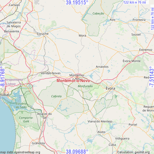
Montemor-o-Novo GPS coordinates[2]
38° 38' 53.232" North, 8° 12' 52.38" West
| Map corner | latitude | longitude |
|---|---|---|
| Upper-left | 39.19515°, | -8.91768° |
| Center: | 38.64812°, | -8.21455° |
| Lower-right: | 38.09688°, | -7.51143° |
| Map W x H: | 122.1×122.1 km | = 75.9×75.9mi |
| max Lat: | 42.11337° ⇑78.2% North |
| Montemor-o-Novo: | 38.64812° |
| min Lat: | ⇓21.8% South 32.6448° |
| min Long | Montemor-o-Novo | max Long |
| -31.17847° | -8.21455° | -6.27308° |
| W 72.7%⇐ | ⇒27.3% E |
Elevation
Elevation of Montemor-o-Novo is 247 m = 810 ft, and this is 70 m = 230 ft above average elevation for this country.
| Max E: |
1008 m = 3307 ft | 23.5% |
| Montemor-o-Novo | 247 m 810 ft | |
| Avg. | 177 m = 581 ft | |
Min E: |
-128 m = -420 ft | 76.5% |
See also: Portugal elevation on elevation.city.
Geographical zone
Montemor-o-Novo is located in North temperate zone (between Tropic of Cancer and the Arctic Circle). Distance of this Northern Tropic circle is 1691.3 km =1050.9 mi to South.| Distance of | km | miles | from Montemor-o-Novo |
|---|---|---|---|
| North Pole | 5709.8 | 3547.9 | to North |
| Arctic Circle | 3103.9 | 1928.7 | to North |
| Tropic Cancer | 1691.3 | 1050.9 | to South |
| Equator | 4297.3 | 2670.2 | to South |


Nearby cities:
15 places around Montemor-o-Novo: (largest is in red/bold)
• Alcácer do Sal
40.2 km =25 mi,  220°
220°
• Alvito
47.7 km =29.6 mi,  155°
155°
• Arraiolos
21.6 km =13.4 mi,  67°
67°
• Avis
53.1 km =33 mi,  31°
31°
• Comporta
57.9 km =36 mi,  239°
239°
• Coruche
43.9 km =27.3 mi,  322°
322°
• Montargil
47.9 km =29.8 mi,  4°
4°
• Mora
33.1 km =20.6 mi,  7°
7°
• Poceirão
54.2 km =33.7 mi,  292°
292°
• Portel
58.5 km =36.4 mi,  130°
130°
• Redondo
58 km =36 mi,  89°
89°
• Santo André
45.3 km =28.1 mi,  356°
356°
• Vendas Novas
21.4 km =13.3 mi,  278°
278°
• Viana do Alentejo
39.4 km =24.5 mi,  152°
152°
• Évora
28.8 km =17.9 mi,  108°
108°
Sources, notices
• [Note1] Compared only with cities in Portugal existing in our database
• [Src1] Map data: © OpenStreetMap contributors (CC-BY-SA)
• [Src2] Other city data from geonames.org with taken over terms of usage.
• [Src3] Geographical zone / Annual Mean Temperature by Robert A. Rohde @ Wikipedia
