Luso geodata
Luso (Aveiro) is a populated place; located in Portugal in Europe/Lisbon (GMT+1) time zone. With population of 2,593 people, there are 608 cities with bigger population in this country. Compared to other cities in Portugal, 59.4% of cities are located further ↓South; 64.6% of cities are located further ←West and 70.2% of cities have lower elevation than Luso. Note1


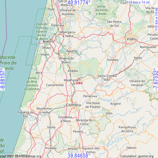
Luso GPS coordinates[2]
40° 23' 3.444" North, 8° 22' 42.42" West
| Map corner | latitude | longitude |
|---|---|---|
| Upper-left | 40.91774°, | -9.08157° |
| Center: | 40.38429°, | -8.37845° |
| Lower-right: | 39.84658°, | -7.67532° |
| Map W x H: | 119.1×119.1 km | = 74×74mi |
| max Lat: | 42.11337° ⇑40.6% North |
| Luso: | 40.38429° |
| min Lat: | ⇓59.4% South 32.6448° |
| min Long | Luso | max Long |
| -31.17847° | -8.37845° | -6.27308° |
| W 64.6%⇐ | ⇒35.4% E |
Elevation
Elevation of Luso is 204 m = 669 ft, and this is 27 m = 89 ft above average elevation for this country.
| Max E: |
1008 m = 3307 ft | 29.8% |
| Luso | 204 m 669 ft | |
| Avg. | 177 m = 581 ft | |
Min E: |
-128 m = -420 ft | 70.2% |
See also: Portugal elevation on elevation.city.
Geographical zone
Luso is located in North temperate zone (between Tropic of Cancer and the Arctic Circle). Distance of this Northern Tropic circle is 1884.4 km =1170.9 mi to South.| Distance of | km | miles | from Luso |
|---|---|---|---|
| North Pole | 5516.7 | 3427.9 | to North |
| Arctic Circle | 2910.9 | 1808.7 | to North |
| Tropic Cancer | 1884.4 | 1170.9 | to South |
| Equator | 4490.3 | 2790.1 | to South |


Nearby cities:
15 places around Luso: (largest is in red/bold)
• Aguada de Cima
16 km =9.9 mi,  345°
345°
• Anadia
7.6 km =4.7 mi,  322°
322°
• Ançã
17.4 km =10.8 mi,  223°
223°
• Arcos
8.9 km =5.5 mi, 322°
• Belazaima do Chão
16.5 km =10.3 mi,  3°
3°
• Friumes
18.6 km =11.6 mi,  132°
132°
• Lorvão
14.8 km =9.2 mi,  159°
159°
• Mealhada
6.1 km =3.8 mi,  263°
263°
• Mortágua
12.5 km =7.8 mi,  83°
83°
• Oliveira do Bairro
17.5 km =10.9 mi,  326°
326°
• Oliveira do Mondego
14.8 km =9.2 mi,  117°
117°
• Pampilhosa do Botão
6.8 km =4.2 mi, 217°
• Penacova
15.2 km =9.4 mi,  147°
147°
• Sangalhos
13.8 km =8.6 mi, 325°
• Travanca
17.6 km =10.9 mi,  112°
112°
Sources, notices
• [Note1] Compared only with cities in Portugal existing in our database
• [Src1] Map data: © OpenStreetMap contributors (CC-BY-SA)
• [Src2] Other city data from geonames.org with taken over terms of usage.
• [Src3] Geographical zone / Annual Mean Temperature by Robert A. Rohde @ Wikipedia
