Anadia geodata
Anadia (Aveiro) is a seat of a second-order administrative division; located in Portugal in Europe/Lisbon (GMT+1) time zone. In our database, there are 824 cities with bigger population. Compared to other cities in Portugal, 60.5% of cities are located further ↓South; 60.3% of cities are located further ←West and 70.5% of cities have higher elevation than Anadia. Note1


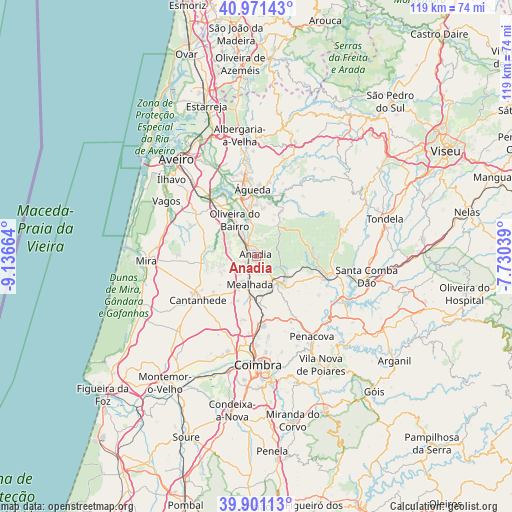
Anadia GPS coordinates[2]
40° 26' 18.276" North, 8° 26' 0.672" West
| Map corner | latitude | longitude |
|---|---|---|
| Upper-left | 40.97143°, | -9.13664° |
| Center: | 40.43841°, | -8.43352° |
| Lower-right: | 39.90113°, | -7.73039° |
| Map W x H: | 119×119 km | = 73.9×73.9mi |
| max Lat: | 42.11337° ⇑39.5% North |
| Anadia: | 40.43841° |
| min Lat: | ⇓60.5% South 32.6448° |
| min Long | Anadia | max Long |
| -31.17847° | -8.43352° | -6.27308° |
| W 60.3%⇐ | ⇒39.7% E |
Elevation
Elevation of Anadia is 49 m = 161 ft, and this is 128 m = 420 ft below average elevation for this country.
| Max E: |
1008 m = 3307 ft | 70.5% |
| Avg. | 177 m = 581 ft | |
| Anadia | 49 m = 161 ft | |
Min E: |
-128 m = -420 ft | 29.5% |
See also: Portugal elevation on elevation.city.
Geographical zone
Anadia is located in North temperate zone (between Tropic of Cancer and the Arctic Circle). Distance of this Northern Tropic circle is 1890.4 km =1174.6 mi to South.| Distance of | km | miles | from Anadia |
|---|---|---|---|
| North Pole | 5510.7 | 3424.2 | to North |
| Arctic Circle | 2904.8 | 1805 | to North |
| Tropic Cancer | 1890.4 | 1174.6 | to South |
| Equator | 4496.3 | 2793.9 | to South |


Nearby cities:
15 places around Anadia: (largest is in red/bold)
• Aguada de Cima
9.4 km =5.8 mi,  3°
3°
• Ançã
20 km =12.4 mi,  201°
201°
• Arcos
1.3 km =0.8 mi,  326°
326°
• Belazaima do Chão
11.9 km =7.4 mi,  28°
28°
• Cantanhede
17 km =10.6 mi,  233°
233°
• Luso
7.6 km =4.7 mi,  142°
142°
• Mealhada
6.9 km =4.3 mi,  191°
191°
• Mortágua
17.6 km =10.9 mi,  105°
105°
• Oiã
14.6 km =9.1 mi,  322°
322°
• Oliveira do Bairro
9.9 km =6.2 mi, 328°
• Oliveira do Mondego
21.9 km =13.6 mi,  125°
125°
• Pampilhosa do Botão
11.4 km =7.1 mi,  177°
177°
• Sangalhos
6.2 km =3.9 mi, 330°
• Valongo
19.9 km =12.4 mi,  355°
355°
• Águeda
15.5 km =9.6 mi, 356°
Sources, notices
• [Note1] Compared only with cities in Portugal existing in our database
• [Src1] Map data: © OpenStreetMap contributors (CC-BY-SA)
• [Src2] Other city data from geonames.org with taken over terms of usage.
• [Src3] Geographical zone / Annual Mean Temperature by Robert A. Rohde @ Wikipedia
