Pampilhosa do Botão geodata
Pampilhosa do Botão (Aveiro) is a populated place; located in Portugal in Europe/Lisbon (GMT+1) time zone. With population of 4,512 people, there are 471 cities with bigger population in this country. Compared to other cities in Portugal, 58.6% of cities are located further ↓South; 60.6% of cities are located further ←West and 61.8% of cities have higher elevation than Pampilhosa do Botão. Note1


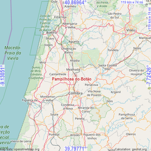
Pampilhosa do Botão GPS coordinates[2]
40° 20' 8.88" North, 8° 25' 38.568" West
| Map corner | latitude | longitude |
|---|---|---|
| Upper-left | 40.86964°, | -9.13051° |
| Center: | 40.3358°, | -8.42738° |
| Lower-right: | 39.79771°, | -7.72426° |
| Map W x H: | 119.2×119.2 km | = 74.1×74.1mi |
| max Lat: | 42.11337° ⇑41.4% North |
| Pampilhosa do Botão: | 40.3358° |
| min Lat: | ⇓58.6% South 32.6448° |
| min Long | Pampilhosa do B | max Long |
| -31.17847° | -8.42738° | -6.27308° |
| W 60.6%⇐ | ⇒39.4% E |
Elevation
Elevation of Pampilhosa do Botão is 73 m = 240 ft, and this is 104 m = 341 ft below average elevation for this country.
| Max E: |
1008 m = 3307 ft | 61.8% |
| Avg. | 177 m = 581 ft | |
| Pampilhosa do Botão | 73 m = 240 ft | |
Min E: |
-128 m = -420 ft | 38.2% |
See also: Portugal elevation on elevation.city.
Geographical zone
Pampilhosa do Botão is located in North temperate zone (between Tropic of Cancer and the Arctic Circle). Distance of this Northern Tropic circle is 1879 km =1167.6 mi to South.| Distance of | km | miles | from Pampilhosa do Botão |
|---|---|---|---|
| North Pole | 5522.1 | 3431.3 | to North |
| Arctic Circle | 2916.3 | 1812.1 | to North |
| Tropic Cancer | 1879 | 1167.6 | to South |
| Equator | 4484.9 | 2786.8 | to South |


Nearby cities:
15 places around Pampilhosa do Botão: (largest is in red/bold)
• Anadia
11.4 km =7.1 mi,  357°
357°
• Ançã
10.7 km =6.6 mi,  228°
228°
• Arcos
12.5 km =7.8 mi,  354°
354°
• Cantanhede
14.2 km =8.8 mi,  274°
274°
• Coimbra
14.5 km =9 mi,  177°
177°
• Friumes
19.3 km =12 mi,  111°
111°
• Lorvão
12.7 km =7.9 mi,  132°
132°
• Luso
6.8 km =4.2 mi,  37°
37°
• Mealhada
5.1 km =3.2 mi,  337°
337°
• Mortágua
17.9 km =11.1 mi,  67°
67°
• Oliveira do Mondego
17.3 km =10.7 mi,  94°
94°
• Penacova
14.4 km =8.9 mi,  121°
121°
• Sangalhos
17.2 km =10.7 mi, 347°
• Santa Clara
15.2 km =9.4 mi, 184°
• Santo António dos Olivais
13.2 km =8.2 mi,  171°
171°
Sources, notices
• [Note1] Compared only with cities in Portugal existing in our database
• [Src1] Map data: © OpenStreetMap contributors (CC-BY-SA)
• [Src2] Other city data from geonames.org with taken over terms of usage.
• [Src3] Geographical zone / Annual Mean Temperature by Robert A. Rohde @ Wikipedia
