Mealhada geodata
Mealhada (Aveiro) is a seat of a second-order administrative division; located in Portugal in Europe/Lisbon (GMT+1) time zone. With population of 4,443 people, there are 477 cities with bigger population in this country. Compared to other cities in Portugal, 59.3% of cities are located further ↓South; 58.7% of cities are located further ←West and 68.2% of cities have higher elevation than Mealhada. Note1


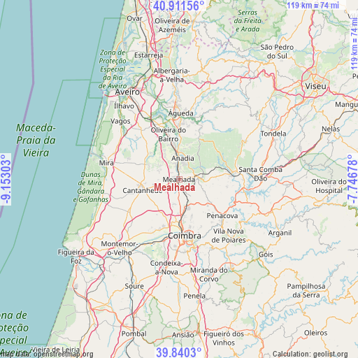
Mealhada GPS coordinates[2]
40° 22' 41.016" North, 8° 26' 59.676" West
| Map corner | latitude | longitude |
|---|---|---|
| Upper-left | 40.91156°, | -9.15303° |
| Center: | 40.37806°, | -8.44991° |
| Lower-right: | 39.8403°, | -7.74678° |
| Map W x H: | 119.1×119.1 km | = 74×74mi |
| max Lat: | 42.11337° ⇑40.7% North |
| Mealhada: | 40.37806° |
| min Lat: | ⇓59.3% South 32.6448° |
| min Long | Mealhada | max Long |
| -31.17847° | -8.44991° | -6.27308° |
| W 58.7%⇐ | ⇒41.3% E |
Elevation
Elevation of Mealhada is 54 m = 177 ft, and this is 123 m = 404 ft below average elevation for this country.
| Max E: |
1008 m = 3307 ft | 68.2% |
| Avg. | 177 m = 581 ft | |
| Mealhada | 54 m = 177 ft | |
Min E: |
-128 m = -420 ft | 31.8% |
See also: Portugal elevation on elevation.city.
Geographical zone
Mealhada is located in North temperate zone (between Tropic of Cancer and the Arctic Circle). Distance of this Northern Tropic circle is 1883.7 km =1170.5 mi to South.| Distance of | km | miles | from Mealhada |
|---|---|---|---|
| North Pole | 5517.4 | 3428.4 | to North |
| Arctic Circle | 2911.6 | 1809.2 | to North |
| Tropic Cancer | 1883.7 | 1170.5 | to South |
| Equator | 4489.6 | 2789.7 | to South |


Nearby cities:
15 places around Mealhada: (largest is in red/bold)
• Aguada de Cima
16.2 km =10.1 mi,  6°
6°
• Anadia
6.9 km =4.3 mi, 11°
• Ançã
13.3 km =8.3 mi,  206°
206°
• Arcos
7.8 km =4.8 mi, 5°
• Belazaima do Chão
18.6 km =11.6 mi,  22°
22°
• Cantanhede
12.7 km =7.9 mi,  254°
254°
• Coimbra
19.3 km =12 mi,  172°
172°
• Lorvão
17.4 km =10.8 mi,  139°
139°
• Luso
6.1 km =3.8 mi,  83°
83°
• Mortágua
18.5 km =11.5 mi, 83°
• Oliveira do Bairro
15.6 km =9.7 mi,  346°
346°
• Pampilhosa do Botão
5.1 km =3.2 mi,  157°
157°
• Penacova
18.7 km =11.6 mi,  130°
130°
• Sangalhos
12.2 km =7.6 mi, 352°
• Santo António dos Olivais
18.2 km =11.3 mi, 167°
Sources, notices
• [Note1] Compared only with cities in Portugal existing in our database
• [Src1] Map data: © OpenStreetMap contributors (CC-BY-SA)
• [Src2] Other city data from geonames.org with taken over terms of usage.
• [Src3] Geographical zone / Annual Mean Temperature by Robert A. Rohde @ Wikipedia
