Bački Breg geodata
Bački Breg (Vojvodina) is a populated place; located in Serbia in Europe/Belgrade (GMT+2) time zone. With population of 1,770 people, there are 232 cities with bigger population in this country. Compared to other cities in Serbia, 97.3% of cities are located further ↓South; 99.8% of cities are located further →East and 51.2% of cities have higher elevation than Bački Breg. Note1


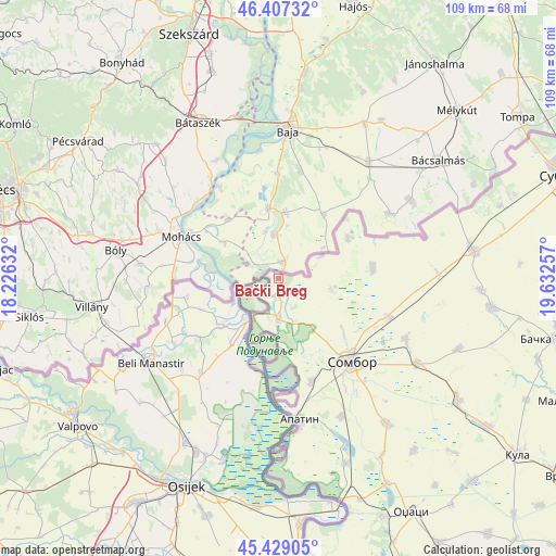
Bački Breg GPS coordinates[2]
45° 55' 13.224" North, 18° 55' 45.984" East
| Map corner | latitude | longitude |
|---|---|---|
| Upper-left | 46.40732°, | 18.22632° |
| Center: | 45.92034°, | 18.92944° |
| Lower-right: | 45.42905°, | 19.63257° |
| Map W x H: | 108.8×108.8 km | = 67.6×67.6mi |
| max Lat: | 46.1° ⇑2.7% North |
| Bački Breg: | 45.92034° |
| min Lat: | ⇓97.3% South 42.25846° |
| min Long | Bački Breg | max Long |
| 18.9276° | 18.92944° | 22.77556° |
| W 0.2%⇐ | ⇒99.8% E |
Elevation
Elevation of Bački Breg is 88 m = 289 ft, and this is 88.4 m = 290 ft below average elevation for this country.
| Max E: |
1421 m = 4662 ft | 51.2% |
| Avg. | 176.4 m = 579 ft | |
| Bački Breg | 88 m = 289 ft | |
Min E: |
49 m = 161 ft | 48.8% |
See also: Serbia elevation on elevation.city.
Geographical zone
Bački Breg is located in North temperate zone (between Tropic of Cancer and the Arctic Circle). Distance of this North polar circle is 2295.3 km =1426.2 mi to North.| Distance of | km | miles | from Bački Breg |
|---|---|---|---|
| North Pole | 4901.2 | 3045.5 | to North |
| Arctic Circle | 2295.3 | 1426.2 | to North |
| Tropic Cancer | 2499.9 | 1553.4 | to South |
| Equator | 5105.9 | 3172.7 | to South |


Nearby cities:
15 places around Bački Breg: (largest is in red/bold)
• Apatin
27.8 km =17.3 mi,  172°
172°
• Bačka Topola
55.6 km =34.5 mi,  102°
102°
• Bogojevo
46.1 km =28.6 mi,  160°
160°
• Doroslovo
40.2 km =25 mi,  150°
150°
• Gakovo
10.4 km =6.5 mi, 102°
• Kolut
3.1 km =1.9 mi,  182°
182°
• Kula
57.8 km =35.9 mi,  126°
126°
• Kupusina
21.3 km =13.2 mi, 162°
• Odžaci
52.7 km =32.7 mi, 150°
• Prigrevica
29.8 km =18.5 mi, 155°
• Riđica
15.8 km =9.8 mi,  60°
60°
• Sombor
21.6 km =13.4 mi,  138°
138°
• Sonta
38.5 km =23.9 mi, 160°
• Stanišić
18.5 km =11.5 mi,  83°
83°
• Subotica
60.3 km =37.5 mi,  70°
70°
Sources, notices
• [Note1] Compared only with cities in Serbia existing in our database
• [Src1] Map data: © OpenStreetMap contributors (CC-BY-SA)
• [Src2] Other city data from geonames.org with taken over terms of usage.
• [Src3] Geographical zone / Annual Mean Temperature by Robert A. Rohde @ Wikipedia
