Kladovo geodata
Kladovo (Central Serbia) is a seat of a third-order administrative division; located in Serbia in Europe/Belgrade (GMT+2) time zone. In our database, there are 365 cities with bigger population. Compared to other cities in Serbia, 64.4% of cities are located further ↑North; 99.8% of cities are located further ←West and 99.8% of cities have higher elevation than Kladovo. Note1


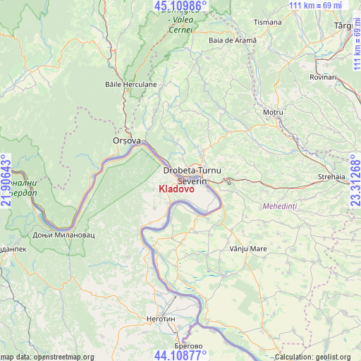
Kladovo GPS coordinates[2]
44° 36' 41.292" North, 22° 36' 34.38" East
| Map corner | latitude | longitude |
|---|---|---|
| Upper-left | 45.10986°, | 21.90643° |
| Center: | 44.61147°, | 22.60955° |
| Lower-right: | 44.10877°, | 23.31268° |
| Map W x H: | 111.3×111.3 km | = 69.2×69.2mi |
| max Lat: | 46.1° ⇑64.4% North |
| Kladovo: | 44.61147° |
| min Lat: | ⇓35.6% South 42.25846° |
| min Long | Kladovo | max Long |
| 18.9276° | 22.60955° | 22.77556° |
| W 99.8%⇐ | ⇒0.2% E |
Elevation
Elevation of Kladovo is 55 m = 180 ft, and this is 121.4 m = 398 ft below average elevation for this country.
| Max E: |
1421 m = 4662 ft | 99.8% |
| Avg. | 176.4 m = 579 ft | |
| Kladovo | 55 m = 180 ft | |
Min E: |
49 m = 161 ft | 0.2% |
See also: Serbia elevation on elevation.city.
Geographical zone
Kladovo is located in North temperate zone (between Tropic of Cancer and the Arctic Circle). Distance of this Northern Tropic circle is 2354.4 km =1463 mi to South.| Distance of | km | miles | from Kladovo |
|---|---|---|---|
| North Pole | 5046.7 | 3135.9 | to North |
| Arctic Circle | 2440.8 | 1516.6 | to North |
| Tropic Cancer | 2354.4 | 1463 | to South |
| Equator | 4960.3 | 3082.2 | to South |


Nearby cities:
15 places around Kladovo: (largest is in red/bold)
• Bela Crkva
99.4 km =61.8 mi,  288°
288°
• Bor
72.3 km =44.9 mi,  214°
214°
• Donji Milanovac
39.7 km =24.7 mi,  245°
245°
• Duboka
68 km =42.3 mi,  261°
261°
• Golubac
77.5 km =48.2 mi,  273°
273°
• Kučevo
75.9 km =47.2 mi, 258°
• Majdanpek
56.4 km =35 mi, 248°
• Negotin
43.3 km =26.9 mi,  188°
188°
• Petrovac
97.9 km =60.8 mi, 254°
• Radenka
67 km =41.6 mi, 267°
• Turija
77.5 km =48.2 mi, 262°
• Veliko Gradište
88 km =54.7 mi,  281°
281°
• Zaječar
83.4 km =51.8 mi,  199°
199°
• Ševica
71.2 km =44.2 mi, 260°
• Žagubica
79.9 km =49.6 mi,  234°
234°
Sources, notices
• [Note1] Compared only with cities in Serbia existing in our database
• [Src1] Map data: © OpenStreetMap contributors (CC-BY-SA)
• [Src2] Other city data from geonames.org with taken over terms of usage.
• [Src3] Geographical zone / Annual Mean Temperature by Robert A. Rohde @ Wikipedia
