Ust’-Barguzin geodata
Ust’-Barguzin (Buryatiya Republic) is a populated place; located in Russia in Asia/Irkutsk (GMT+8) time zone. With population of 7,195 people, there are 1953 cities with bigger population in this country. Compared to other cities in Russia, 59.5% of cities are located further ↑North; 91% of cities are located further ←West and 90.3% of cities have lower elevation than Ust’-Barguzin. Note1


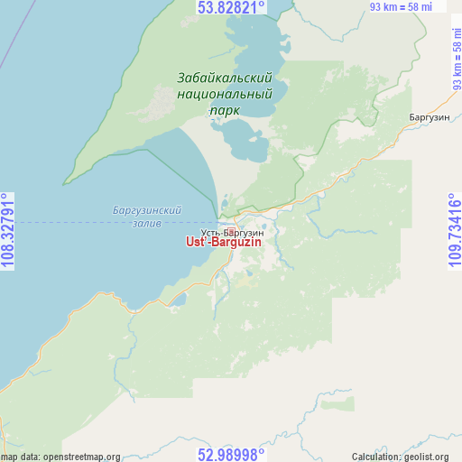
Ust’-Barguzin GPS coordinates[2]
53° 24' 40.176" North, 109° 1' 51.708" East
| Map corner | latitude | longitude |
|---|---|---|
| Upper-left | 53.82821°, | 108.32791° |
| Center: | 53.41116°, | 109.03103° |
| Lower-right: | 52.98998°, | 109.73416° |
| Map W x H: | 93.2×93.2 km | = 57.9×57.9mi |
| max Lat: | 73.50819° ⇑59.5% North |
| Ust’-Barguzin: | 53.41116° |
| min Lat: | ⇓40.5% South 41.28413° |
| min Long | Ust’-Barguzin | max Long |
| -179.12198° | 109.03103° | 179.35046° |
| W 91%⇐ | ⇒9% E |
Elevation
Elevation of Ust’-Barguzin is 459 m = 1506 ft, and this is 256.4 m = 841 ft above average elevation for this country.
| Max E: |
2518 m = 8261 ft | 9.7% |
| Ust’-Barguzin | 459 m 1506 ft | |
| Avg. | 202.6 m = 665 ft | |
Min E: |
-28 m = -92 ft | 90.3% |
See also: Russia elevation on elevation.city.
Geographical zone
Ust’-Barguzin is located in North temperate zone (between Tropic of Cancer and the Arctic Circle). Distance of this North polar circle is 1462.4 km =908.7 mi to North.| Distance of | km | miles | from Ust’-Barguzin |
|---|---|---|---|
| North Pole | 4068.3 | 2527.9 | to North |
| Arctic Circle | 1462.4 | 908.7 | to North |
| Tropic Cancer | 3332.8 | 2070.9 | to South |
| Equator | 5938.8 | 3690.2 | to South |


Nearby cities:
15 places around Ust’-Barguzin: (largest is in red/bold)
• Barguzin
46.4 km =28.8 mi,  60°
60°
• Biryul’ka
184.8 km =114.8 mi,  285°
285°
• Il’inka
186.1 km =115.6 mi,  219°
219°
• Il’ka
191 km =118.7 mi,  190°
190°
• Khorinsk
147.2 km =91.5 mi,  160°
160°
• Khuzhir
114.9 km =71.4 mi,  257°
257°
• Kizhinga
183.6 km =114.1 mi, 161°
• Kurumkan
131.2 km =81.5 mi,  39°
39°
• Onokhoy
177.2 km =110.1 mi,  201°
201°
• Sosnovo-Ozerskoye
194.8 km =121 mi,  120°
120°
• Tataurovo
177.1 km =110 mi, 217°
• Turka
74.5 km =46.3 mi,  226°
226°
• Turuntayevo
163.6 km =101.7 mi,  214°
214°
• Yelantsy
187.9 km =116.8 mi,  248°
248°
• Zaigrayevo
182.7 km =113.5 mi, 196°
Sources, notices
• [Note1] Compared only with cities in Russia existing in our database
• [Src1] Map data: © OpenStreetMap contributors (CC-BY-SA)
• [Src2] Other city data from geonames.org with taken over terms of usage.
• [Src3] Geographical zone / Annual Mean Temperature by Robert A. Rohde @ Wikipedia
