Tuma geodata
Tuma (Ryazan Oblast) is a populated place; located in Russia in Europe/Moscow (GMT+3) time zone. With population of 6,432 people, there are 2147 cities with bigger population in this country. Compared to other cities in Russia, 54.8% of cities are located further ↓South; 64.7% of cities are located further →East and 59.6% of cities have higher elevation than Tuma. Note1


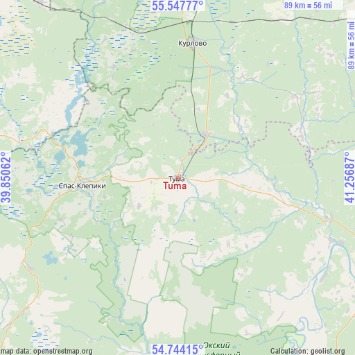
Tuma GPS coordinates[2]
55° 8' 52.728" North, 40° 33' 13.464" East
| Map corner | latitude | longitude |
|---|---|---|
| Upper-left | 55.54777°, | 39.85062° |
| Center: | 55.14798°, | 40.55374° |
| Lower-right: | 54.74415°, | 41.25687° |
| Map W x H: | 89.4×89.4 km | = 55.6×55.6mi |
| max Lat: | 73.50819° ⇑45.2% North |
| Tuma: | 55.14798° |
| min Lat: | ⇓54.8% South 41.28413° |
| min Long | Tuma | max Long |
| -179.12198° | 40.55374° | 179.35046° |
| W 35.3%⇐ | ⇒64.7% E |
Elevation
Elevation of Tuma is 125 m = 410 ft, and this is 77.6 m = 255 ft below average elevation for this country.
| Max E: |
2518 m = 8261 ft | 59.6% |
| Avg. | 202.6 m = 665 ft | |
| Tuma | 125 m = 410 ft | |
Min E: |
-28 m = -92 ft | 40.4% |
See also: Russia elevation on elevation.city.
Geographical zone
Tuma is located in North temperate zone (between Tropic of Cancer and the Arctic Circle). Distance of this North polar circle is 1269.3 km =788.7 mi to North.| Distance of | km | miles | from Tuma |
|---|---|---|---|
| North Pole | 3875.2 | 2407.9 | to North |
| Arctic Circle | 1269.3 | 788.7 | to North |
| Tropic Cancer | 3526 | 2191 | to South |
| Equator | 6131.9 | 3810.2 | to South |


Nearby cities:
15 places around Tuma: (largest is in red/bold)
• Cherusti
56.3 km =35 mi,  322°
322°
• Dmitrovskiy Pogost
49.2 km =30.6 mi,  291°
291°
• Erleks
51.6 km =32.1 mi,  348°
348°
• Gusevskiy
57.2 km =35.5 mi,  0°
0°
• Gus’-Khrustal’nyy
51.9 km =32.2 mi,  6°
6°
• Gus’-Zheleznyy
40.2 km =25 mi,  104°
104°
• Kurlovo
31.9 km =19.8 mi, 352°
• Lashma
44.6 km =27.7 mi,  122°
122°
• Mezinovskiy
41.5 km =25.8 mi,  342°
342°
• Radovitskiy
48.2 km =30 mi,  267°
267°
• Savinskaya
43.3 km =26.9 mi,  304°
304°
• Spas-Klepiki
24 km =14.9 mi, 266°
• Syntul
50 km =31.1 mi,  108°
108°
• Velikodvorskiy
13.5 km =8.4 mi,  32°
32°
• Zolotkovo
54.8 km =34.1 mi,  39°
39°
Sources, notices
• [Note1] Compared only with cities in Russia existing in our database
• [Src1] Map data: © OpenStreetMap contributors (CC-BY-SA)
• [Src2] Other city data from geonames.org with taken over terms of usage.
• [Src3] Geographical zone / Annual Mean Temperature by Robert A. Rohde @ Wikipedia
