Engozero geodata
Engozero (Karelia) is a populated place; located in Russia in Europe/Moscow (GMT+3) time zone. With population of 663 people, there are 4848 cities with bigger population in this country. Compared to other cities in Russia, 97.9% of cities are located further ↓South; 90.7% of cities are located further →East and 79% of cities have higher elevation than Engozero. Note1


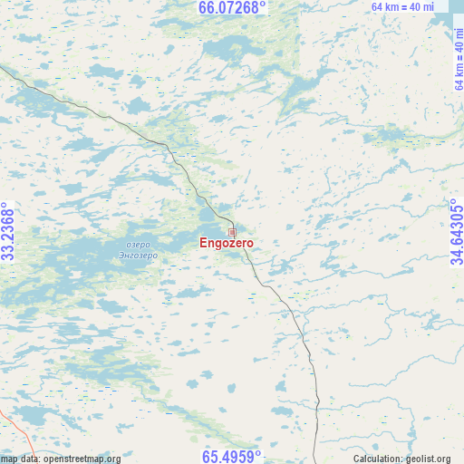
Engozero GPS coordinates[2]
65° 47' 9.24" North, 33° 56' 23.712" East
| Map corner | latitude | longitude |
|---|---|---|
| Upper-left | 66.07268°, | 33.2368° |
| Center: | 65.7859°, | 33.93992° |
| Lower-right: | 65.4959°, | 34.64305° |
| Map W x H: | 64.1×64.1 km | = 39.8×39.8mi |
| max Lat: | 73.50819° ⇑2.1% North |
| Engozero: | 65.7859° |
| min Lat: | ⇓97.9% South 41.28413° |
| min Long | Engozero | max Long |
| -179.12198° | 33.93992° | 179.35046° |
| W 9.3%⇐ | ⇒90.7% E |
Elevation
Elevation of Engozero is 74 m = 243 ft, and this is 128.6 m = 422 ft below average elevation for this country.
| Max E: |
2518 m = 8261 ft | 79% |
| Avg. | 202.6 m = 665 ft | |
| Engozero | 74 m = 243 ft | |
Min E: |
-28 m = -92 ft | 21% |
See also: Russia elevation on elevation.city.
Geographical zone
Engozero is located in North temperate zone (between Tropic of Cancer and the Arctic Circle). Distance of this North polar circle is 86.5 km =53.7 mi to North.| Distance of | km | miles | from Engozero |
|---|---|---|---|
| North Pole | 2692.4 | 1673 | to North |
| Arctic Circle | 86.5 | 53.7 | to North |
| Tropic Cancer | 4708.8 | 2925.9 | to South |
| Equator | 7314.7 | 4545.1 | to South |


Nearby cities:
15 places around Engozero: (largest is in red/bold)
• Ambarnyy
15.6 km =9.7 mi,  321°
321°
• Belomorsk
145.6 km =90.5 mi,  164°
164°
• Borovoy
152.5 km =94.8 mi,  211°
211°
• Chupa
67.1 km =41.7 mi, 323°
• Kalevala
142.6 km =88.6 mi,  242°
242°
• Kandalaksha
167.3 km =104 mi,  336°
336°
• Kem’
97 km =60.3 mi, 162°
• Loukhi
51.8 km =32.2 mi,  308°
308°
• Poyakonda
103 km =64 mi,  330°
330°
• Pyaozerskiy
130 km =80.8 mi,  269°
269°
• Rabocheostrovsk
96.9 km =60.2 mi, 156°
• Solovetsky
117.7 km =73.1 mi,  135°
135°
• Umba
101.8 km =63.3 mi,  10°
10°
• Yushkozero
143.3 km =89 mi,  216°
216°
• Zelenoborskiy
137.2 km =85.3 mi, 329°
Sources, notices
• [Note1] Compared only with cities in Russia existing in our database
• [Src1] Map data: © OpenStreetMap contributors (CC-BY-SA)
• [Src2] Other city data from geonames.org with taken over terms of usage.
• [Src3] Geographical zone / Annual Mean Temperature by Robert A. Rohde @ Wikipedia
