Shentala geodata
Shentala (Samara Oblast) is a populated place; located in Russia in Europe/Samara (GMT+4) time zone. With population of 6,595 people, there are 2100 cities with bigger population in this country. Compared to other cities in Russia, 51.4% of cities are located further ↑North; 63.5% of cities are located further ←West and 78.9% of cities have lower elevation than Shentala. Note1


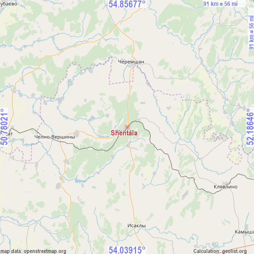
Shentala GPS coordinates[2]
54° 27' 0" North, 51° 28' 59.988" East
| Map corner | latitude | longitude |
|---|---|---|
| Upper-left | 54.85677°, | 50.78021° |
| Center: | 54.45°, | 51.48333° |
| Lower-right: | 54.03915°, | 52.18646° |
| Map W x H: | 90.9×90.9 km | = 56.5×56.5mi |
| max Lat: | 73.50819° ⇑51.4% North |
| Shentala: | 54.45° |
| min Lat: | ⇓48.6% South 41.28413° |
| min Long | Shentala | max Long |
| -179.12198° | 51.48333° | 179.35046° |
| W 63.5%⇐ | ⇒36.5% E |
Elevation
Elevation of Shentala is 240 m = 787 ft, and this is 37.4 m = 123 ft above average elevation for this country.
| Max E: |
2518 m = 8261 ft | 21.1% |
| Shentala | 240 m 787 ft | |
| Avg. | 202.6 m = 665 ft | |
Min E: |
-28 m = -92 ft | 78.9% |
See also: Russia elevation on elevation.city.
Geographical zone
Shentala is located in North temperate zone (between Tropic of Cancer and the Arctic Circle). Distance of this North polar circle is 1346.9 km =836.9 mi to North.| Distance of | km | miles | from Shentala |
|---|---|---|---|
| North Pole | 3952.8 | 2456.2 | to North |
| Arctic Circle | 1346.9 | 836.9 | to North |
| Tropic Cancer | 3448.4 | 2142.7 | to South |
| Equator | 6054.3 | 3762 | to South |


Nearby cities:
15 places around Shentala: (largest is in red/bold)
• Al’met’yevsk
73.6 km =45.7 mi,  46°
46°
• Chelno-Vershiny
26 km =16.2 mi,  261°
261°
• Cheremshan
24.1 km =15 mi,  2°
2°
• Isakly
35.4 km =22 mi,  174°
174°
• Kamyshla
56.6 km =35.2 mi,  130°
130°
• Karabash
75.9 km =47.2 mi,  69°
69°
• Klyavlino
40.8 km =25.4 mi,  120°
120°
• Koshki
71.1 km =44.2 mi,  247°
247°
• Leninogorsk
65.3 km =40.6 mi, 74°
• Novosheshminsk
70.2 km =43.6 mi,  346°
346°
• Nurlat
43.9 km =27.3 mi,  266°
266°
• Sernovodsk
60.4 km =37.5 mi,  194°
194°
• Shugurovo
42.4 km =26.3 mi,  81°
81°
• Sukhodol
63.6 km =39.5 mi,  196°
196°
• Surgut
61.2 km =38 mi, 197°
Sources, notices
• [Note1] Compared only with cities in Russia existing in our database
• [Src1] Map data: © OpenStreetMap contributors (CC-BY-SA)
• [Src2] Other city data from geonames.org with taken over terms of usage.
• [Src3] Geographical zone / Annual Mean Temperature by Robert A. Rohde @ Wikipedia
