Nizhniy Chir geodata
Nizhniy Chir (Volgograd Oblast) is a populated place; located in Russia in Europe/Volgograd (GMT+3) time zone. With population of 4,765 people, there are 2750 cities with bigger population in this country. Compared to other cities in Russia, 80% of cities are located further ↑North; 56.4% of cities are located further →East and 77.5% of cities have higher elevation than Nizhniy Chir. Note1


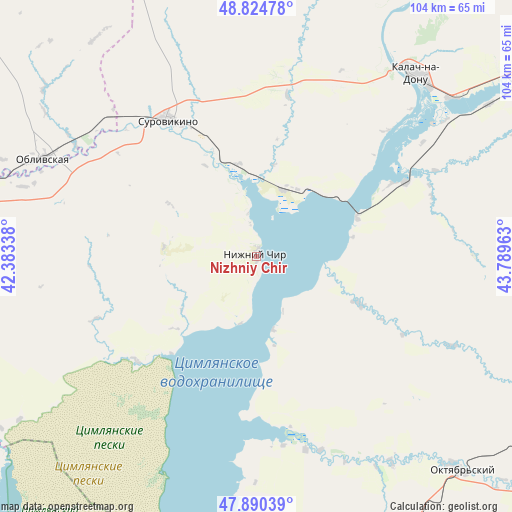
Nizhniy Chir GPS coordinates[2]
48° 21' 35.028" North, 43° 5' 11.4" East
| Map corner | latitude | longitude |
|---|---|---|
| Upper-left | 48.82478°, | 42.38338° |
| Center: | 48.35973°, | 43.0865° |
| Lower-right: | 47.89039°, | 43.78963° |
| Map W x H: | 103.9×103.9 km | = 64.6×64.6mi |
| max Lat: | 73.50819° ⇑80% North |
| Nizhniy Chir: | 48.35973° |
| min Lat: | ⇓20% South 41.28413° |
| min Long | Nizhniy Chir | max Long |
| -179.12198° | 43.0865° | 179.35046° |
| W 43.6%⇐ | ⇒56.4% E |
Elevation
Elevation of Nizhniy Chir is 79 m = 259 ft, and this is 123.6 m = 406 ft below average elevation for this country.
| Max E: |
2518 m = 8261 ft | 77.5% |
| Avg. | 202.6 m = 665 ft | |
| Nizhniy Chir | 79 m = 259 ft | |
Min E: |
-28 m = -92 ft | 22.5% |
See also: Russia elevation on elevation.city.
Geographical zone
Nizhniy Chir is located in North temperate zone (between Tropic of Cancer and the Arctic Circle). Distance of this North polar circle is 2024.1 km =1257.7 mi to North.| Distance of | km | miles | from Nizhniy Chir |
|---|---|---|---|
| North Pole | 4630 | 2876.9 | to North |
| Arctic Circle | 2024.1 | 1257.7 | to North |
| Tropic Cancer | 2771.2 | 1721.9 | to South |
| Equator | 5377.1 | 3341.2 | to South |


Nearby cities:
15 places around Nizhniy Chir: (largest is in red/bold)
• Bereslavka
76.6 km =47.6 mi,  67°
67°
• Chernyshkovskiy
63.6 km =39.5 mi,  276°
276°
• Dubovskoye
107.8 km =67 mi,  192°
192°
• Gumrak
106.3 km =66.1 mi,  63°
63°
• Kalach-na-Donu
49.1 km =30.5 mi,  41°
41°
• Kletskaya
106.2 km =66 mi,  358°
358°
• Kotel’nikovo
81.2 km =50.5 mi,  177°
177°
• Milyutinskaya
108.7 km =67.5 mi,  285°
285°
• Morozovsk
93.1 km =57.8 mi,  269°
269°
• Novyy Rogachik
80 km =49.7 mi, 63°
• Oblivskaya
47.4 km =29.5 mi, 294°
• Oktyabr’skiy
62.2 km =38.6 mi, 58°
• Sovetskaya
101.1 km =62.8 mi,  315°
315°
• Surovikino
32.7 km =20.3 mi,  327°
327°
• Tsimlyansk
108 km =67.1 mi,  222°
222°
Sources, notices
• [Note1] Compared only with cities in Russia existing in our database
• [Src1] Map data: © OpenStreetMap contributors (CC-BY-SA)
• [Src2] Other city data from geonames.org with taken over terms of usage.
• [Src3] Geographical zone / Annual Mean Temperature by Robert A. Rohde @ Wikipedia
