Dubovskoye geodata
Dubovskoye (Rostov) is a seat of a second-order administrative division; located in Russia in Europe/Moscow (GMT+3) time zone. With population of 8,019 people, there are 1793 cities with bigger population in this country. Compared to other cities in Russia, 81.4% of cities are located further ↑North; 57.5% of cities are located further →East and 83.7% of cities have higher elevation than Dubovskoye. Note1


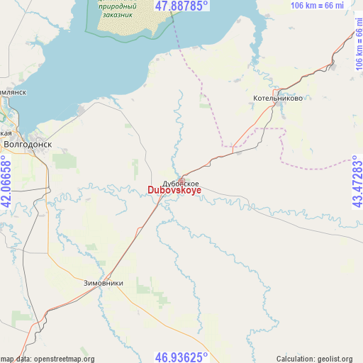
Dubovskoye GPS coordinates[2]
47° 24' 51.12" North, 42° 46' 10.92" East
| Map corner | latitude | longitude |
|---|---|---|
| Upper-left | 47.88785°, | 42.06658° |
| Center: | 47.4142°, | 42.7697° |
| Lower-right: | 46.93625°, | 43.47283° |
| Map W x H: | 105.8×105.8 km | = 65.7×65.7mi |
| max Lat: | 73.50819° ⇑81.4% North |
| Dubovskoye: | 47.4142° |
| min Lat: | ⇓18.6% South 41.28413° |
| min Long | Dubovskoye | max Long |
| -179.12198° | 42.7697° | 179.35046° |
| W 42.5%⇐ | ⇒57.5% E |
Elevation
Elevation of Dubovskoye is 54 m = 177 ft, and this is 148.6 m = 488 ft below average elevation for this country.
| Max E: |
2518 m = 8261 ft | 83.7% |
| Avg. | 202.6 m = 665 ft | |
| Dubovskoye | 54 m = 177 ft | |
Min E: |
-28 m = -92 ft | 16.3% |
See also: Russia elevation on elevation.city.
Geographical zone
Dubovskoye is located in North temperate zone (between Tropic of Cancer and the Arctic Circle). Distance of this North polar circle is 2129.2 km =1323 mi to North.| Distance of | km | miles | from Dubovskoye |
|---|---|---|---|
| North Pole | 4735.1 | 2942.3 | to North |
| Arctic Circle | 2129.2 | 1323 | to North |
| Tropic Cancer | 2666 | 1656.6 | to South |
| Equator | 5272 | 3275.9 | to South |


Nearby cities:
15 places around Dubovskoye: (largest is in red/bold)
• Bol’shaya Martynovka
84.5 km =52.5 mi,  259°
259°
• Gundorovskiy
96.6 km =60 mi,  223°
223°
• Kotel’nikovo
36.8 km =22.9 mi,  49°
49°
• Krasnoarmeyskiy
61.7 km =38.3 mi, 223°
• Krasnoyarskaya
44.8 km =27.8 mi,  281°
281°
• Krasnoyarskaya
60.4 km =37.5 mi,  295°
295°
• Nikolayevskaya
97.7 km =60.7 mi, 283°
• Orlovskiy
80.8 km =50.2 mi, 221°
• Romanovskaya
57.5 km =35.7 mi, 284°
• Sovetskoye
90.3 km =56.1 mi,  211°
211°
• Tsimlyansk
56.4 km =35 mi, 297°
• Volgodonsk
47.8 km =29.7 mi, 283°
• Volochayevskiy
97.1 km =60.3 mi,  185°
185°
• Zavetnoye
90.7 km =56.4 mi,  111°
111°
• Zimovniki
37.2 km =23.1 mi, 217°
Sources, notices
• [Note1] Compared only with cities in Russia existing in our database
• [Src1] Map data: © OpenStreetMap contributors (CC-BY-SA)
• [Src2] Other city data from geonames.org with taken over terms of usage.
• [Src3] Geographical zone / Annual Mean Temperature by Robert A. Rohde @ Wikipedia
