Kama geodata
Kama (Udmurtiya Republic) is a populated place; located in Russia in Europe/Samara (GMT+4) time zone. With population of 3,439 people, there are 3445 cities with bigger population in this country. Compared to other cities in Russia, 70.7% of cities are located further ↓South; 65.7% of cities are located further ←West and 79% of cities have higher elevation than Kama. Note1


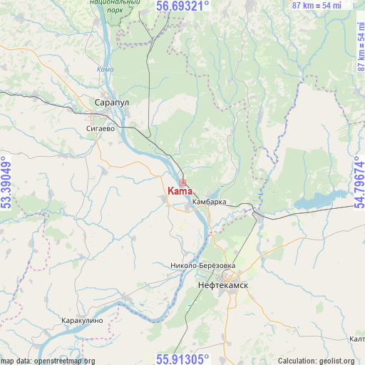
Kama GPS coordinates[2]
56° 18' 18.432" North, 54° 5' 36.996" East
| Map corner | latitude | longitude |
|---|---|---|
| Upper-left | 56.69321°, | 53.39049° |
| Center: | 56.30512°, | 54.09361° |
| Lower-right: | 55.91305°, | 54.79674° |
| Map W x H: | 86.7×86.7 km | = 53.9×53.9mi |
| max Lat: | 73.50819° ⇑29.3% North |
| Kama: | 56.30512° |
| min Lat: | ⇓70.7% South 41.28413° |
| min Long | Kama | max Long |
| -179.12198° | 54.09361° | 179.35046° |
| W 65.7%⇐ | ⇒34.3% E |
Elevation
Elevation of Kama is 74 m = 243 ft, and this is 128.6 m = 422 ft below average elevation for this country.
| Max E: |
2518 m = 8261 ft | 79% |
| Avg. | 202.6 m = 665 ft | |
| Kama | 74 m = 243 ft | |
Min E: |
-28 m = -92 ft | 21% |
See also: Russia elevation on elevation.city.
Geographical zone
Kama is located in North temperate zone (between Tropic of Cancer and the Arctic Circle). Distance of this North polar circle is 1140.6 km =708.7 mi to North.| Distance of | km | miles | from Kama |
|---|---|---|---|
| North Pole | 3746.5 | 2328 | to North |
| Arctic Circle | 1140.6 | 708.7 | to North |
| Tropic Cancer | 3654.6 | 2270.9 | to South |
| Equator | 6260.5 | 3890.1 | to South |


Nearby cities:
15 places around Kama: (largest is in red/bold)
• Agidel’
45.3 km =28.1 mi,  192°
192°
• Aktanysh
64.9 km =40.3 mi,  180°
180°
• Amzya
19.6 km =12.2 mi,  113°
113°
• Chaykovskiy
51.6 km =32.1 mi,  1°
1°
• Foki
45.9 km =28.5 mi,  20°
20°
• Kaltasy
57.7 km =35.9 mi,  130°
130°
• Kambarka
8.1 km =5 mi,  121°
121°
• Karakulino
40.5 km =25.2 mi,  216°
216°
• Kiyasovo
60 km =37.3 mi,  274°
274°
• Krasnokholmskiy
68.8 km =42.8 mi, 120°
• Neftekamsk
26 km =16.2 mi,  155°
155°
• Nikolo-Berëzovka
20.5 km =12.7 mi,  169°
169°
• Sarapul
26.3 km =16.3 mi,  316°
316°
• Sigayevo
23.5 km =14.6 mi,  303°
303°
• Yanaul
52 km =32.3 mi,  93°
93°
Sources, notices
• [Note1] Compared only with cities in Russia existing in our database
• [Src1] Map data: © OpenStreetMap contributors (CC-BY-SA)
• [Src2] Other city data from geonames.org with taken over terms of usage.
• [Src3] Geographical zone / Annual Mean Temperature by Robert A. Rohde @ Wikipedia
