Kambarka geodata
Kambarka (Udmurtiya Republic) is a populated place; located in Russia in Europe/Samara (GMT+4) time zone. With population of 12,464 people, there are 1236 cities with bigger population in this country. Compared to other cities in Russia, 70.2% of cities are located further ↓South; 65.9% of cities are located further ←West and 77.8% of cities have higher elevation than Kambarka. Note1


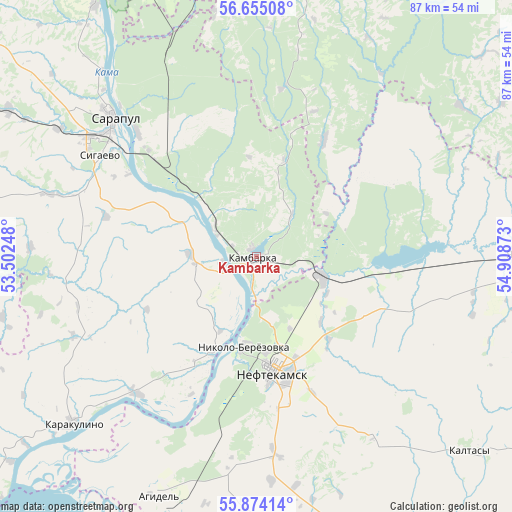
Kambarka GPS coordinates[2]
56° 15' 59.76" North, 54° 12' 20.16" East
| Map corner | latitude | longitude |
|---|---|---|
| Upper-left | 56.65508°, | 53.50248° |
| Center: | 56.2666°, | 54.2056° |
| Lower-right: | 55.87414°, | 54.90873° |
| Map W x H: | 86.8×86.8 km | = 53.9×53.9mi |
| max Lat: | 73.50819° ⇑29.8% North |
| Kambarka: | 56.2666° |
| min Lat: | ⇓70.2% South 41.28413° |
| min Long | Kambarka | max Long |
| -179.12198° | 54.2056° | 179.35046° |
| W 65.9%⇐ | ⇒34.1% E |
Elevation
Elevation of Kambarka is 78 m = 256 ft, and this is 124.6 m = 409 ft below average elevation for this country.
| Max E: |
2518 m = 8261 ft | 77.8% |
| Avg. | 202.6 m = 665 ft | |
| Kambarka | 78 m = 256 ft | |
Min E: |
-28 m = -92 ft | 22.2% |
See also: Russia elevation on elevation.city.
Geographical zone
Kambarka is located in North temperate zone (between Tropic of Cancer and the Arctic Circle). Distance of this North polar circle is 1144.9 km =711.4 mi to North.| Distance of | km | miles | from Kambarka |
|---|---|---|---|
| North Pole | 3750.8 | 2330.6 | to North |
| Arctic Circle | 1144.9 | 711.4 | to North |
| Tropic Cancer | 3650.3 | 2268.2 | to South |
| Equator | 6256.3 | 3887.5 | to South |


Nearby cities:
15 places around Kambarka: (largest is in red/bold)
• Agidel’
43.3 km =26.9 mi,  202°
202°
• Aktanysh
61.1 km =38 mi,  187°
187°
• Amzya
11.6 km =7.2 mi,  107°
107°
• Chaykovskiy
56.1 km =34.9 mi,  354°
354°
• Foki
48.2 km =30 mi,  10°
10°
• Kaltasy
49.7 km =30.9 mi,  131°
131°
• Kama
8.1 km =5 mi,  301°
301°
• Karakulino
41.9 km =26 mi,  227°
227°
• Kiyasovo
67.3 km =41.8 mi,  277°
277°
• Krasnokholmskiy
60.7 km =37.7 mi,  120°
120°
• Neftekamsk
19.8 km =12.3 mi,  169°
169°
• Nikolo-Berëzovka
16.1 km =10 mi, 191°
• Sarapul
34.3 km =21.3 mi,  312°
312°
• Sigayevo
31.6 km =19.6 mi, 303°
• Yanaul
45 km =28 mi,  88°
88°
Sources, notices
• [Note1] Compared only with cities in Russia existing in our database
• [Src1] Map data: © OpenStreetMap contributors (CC-BY-SA)
• [Src2] Other city data from geonames.org with taken over terms of usage.
• [Src3] Geographical zone / Annual Mean Temperature by Robert A. Rohde @ Wikipedia
