Tyazhinskiy geodata
Tyazhinskiy (Kemerovo Oblast) is a populated place; located in Russia in Asia/Novokuznetsk (GMT+7) time zone. With population of 13,716 people, there are 1158 cities with bigger population in this country. Compared to other cities in Russia, 68.2% of cities are located further ↓South; 85.3% of cities are located further ←West and 73.5% of cities have lower elevation than Tyazhinskiy. Note1


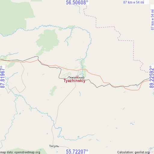
Tyazhinskiy GPS coordinates[2]
56° 6' 57.852" North, 88° 31' 22.044" East
| Map corner | latitude | longitude |
|---|---|---|
| Upper-left | 56.50608°, | 87.81967° |
| Center: | 56.11607°, | 88.52279° |
| Lower-right: | 55.72207°, | 89.22592° |
| Map W x H: | 87.2×87.2 km | = 54.2×54.2mi |
| max Lat: | 73.50819° ⇑31.8% North |
| Tyazhinskiy: | 56.11607° |
| min Lat: | ⇓68.2% South 41.28413° |
| min Long | Tyazhinskiy | max Long |
| -179.12198° | 88.52279° | 179.35046° |
| W 85.3%⇐ | ⇒14.7% E |
Elevation
Elevation of Tyazhinskiy is 210 m = 689 ft, and this is 7.4 m = 24 ft above average elevation for this country.
| Max E: |
2518 m = 8261 ft | 26.5% |
| Tyazhinskiy | 210 m 689 ft | |
| Avg. | 202.6 m = 665 ft | |
Min E: |
-28 m = -92 ft | 73.5% |
See also: Russia elevation on elevation.city.
Geographical zone
Tyazhinskiy is located in North temperate zone (between Tropic of Cancer and the Arctic Circle). Distance of this North polar circle is 1161.7 km =721.8 mi to North.| Distance of | km | miles | from Tyazhinskiy |
|---|---|---|---|
| North Pole | 3767.5 | 2341 | to North |
| Arctic Circle | 1161.7 | 721.8 | to North |
| Tropic Cancer | 3633.6 | 2257.8 | to South |
| Equator | 6239.5 | 3877 | to South |


Nearby cities:
15 places around Tyazhinskiy: (largest is in red/bold)
• Achinsk
123.5 km =76.7 mi,  82°
82°
• Belogorsk
122.1 km =75.9 mi,  180°
180°
• Bogotol
63.4 km =39.4 mi, 80°
• Dubinino
65.6 km =40.8 mi,  147°
147°
• Goryachegorsk
83.1 km =51.6 mi,  162°
162°
• Itatskiy
32.3 km =20.1 mi,  99°
99°
• Izhmorskiy
116.8 km =72.6 mi,  274°
274°
• Mariinsk
49.2 km =30.6 mi,  282°
282°
• Nazarovo
117.2 km =72.8 mi, 95°
• Sharypovo
76.8 km =47.7 mi, 146°
• Suslovo
27.5 km =17.1 mi,  293°
293°
• Tisul’
41.5 km =25.8 mi,  198°
198°
• Tyukhtet
67.7 km =42.1 mi,  45°
45°
• Uzhur
121.3 km =75.4 mi,  137°
137°
• Verkh-Chebula
56.7 km =35.2 mi,  260°
260°
Sources, notices
• [Note1] Compared only with cities in Russia existing in our database
• [Src1] Map data: © OpenStreetMap contributors (CC-BY-SA)
• [Src2] Other city data from geonames.org with taken over terms of usage.
• [Src3] Geographical zone / Annual Mean Temperature by Robert A. Rohde @ Wikipedia
