Afif geodata
Afif (Ar Riyāḑ) is a populated place; located in Saudi Arabia in Asia/Riyadh (GMT+3) time zone. With population of 45,525 people, there are 39 cities with bigger population in this country. Compared to other cities in Saudi Arabia, 69.1% of cities are located further ↑North; 56.7% of cities are located further →East and 87.6% of cities have lower elevation than Afif. Note1


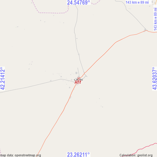
Afif GPS coordinates[2]
23° 54' 23.4" North, 42° 55' 2.064" East
| Map corner | latitude | longitude |
|---|---|---|
| Upper-left | 24.54769°, | 42.21412° |
| Center: | 23.9065°, | 42.91724° |
| Lower-right: | 23.26211°, | 43.62037° |
| Map W x H: | 142.9×142.9 km | = 88.8×88.8mi |
| max Lat: | 31.67252° ⇑69.1% North |
| Afif: | 23.9065° |
| min Lat: | ⇓30.9% South 16.57946° |
| min Long | Afif | max Long |
| 35.69014° | 42.91724° | 54.09599° |
| W 43.3%⇐ | ⇒56.7% E |
Elevation
Elevation of Afif is 1045 m = 3428 ft, and this is 523.6 m = 1718 ft above average elevation for this country.
| Max E: |
2385 m = 7825 ft | 12.4% |
| Afif | 1045 m 3428 ft | |
| Avg. | 521.4 m = 1711 ft | |
Min E: |
3 m = 10 ft | 87.6% |
See also: Afif elevation on elevation.city.
Geographical zone
Afif is located in North temperate zone (between Tropic of Cancer and the Arctic Circle). Distance of this Northern Tropic circle is 52.2 km =32.4 mi to South.| Distance of | km | miles | from Afif |
|---|---|---|---|
| North Pole | 7348.9 | 4566.4 | to North |
| Arctic Circle | 4743 | 2947.2 | to North |
| Tropic Cancer | 52.2 | 32.4 | to South |
| Equator | 2658.2 | 1651.7 | to South |


Nearby cities:
15 places around Afif: (largest is in red/bold)
• Ad Dawādimī
163.9 km =101.8 mi,  65°
65°
• Adh Dhibiyah
237 km =147.3 mi,  5°
5°
• Ain AlBaraha
128.4 km =79.8 mi,  42°
42°
• Al Bukayrīyah
259.2 km =161.1 mi,  16°
16°
• Al Fuwayliq
284.1 km =176.5 mi, 6°
• Al Mithnab
254 km =157.8 mi,  31°
31°
• Al Muwayh
202.1 km =125.6 mi,  215°
215°
• Alrmtheiah
93.1 km =57.8 mi,  2°
2°
• Ar Rass
226 km =140.4 mi, 15°
• Buraydah
289.3 km =179.8 mi, 21°
• Marāt
287.8 km =178.8 mi,  63°
63°
• Sājir
221.5 km =137.6 mi,  50°
50°
• Turabah
327.1 km =203.3 mi,  203°
203°
• Unaizah
264.5 km =164.4 mi, 23°
• Wed Alnkil
169.2 km =105.1 mi,  357°
357°
Sources, notices
• [Note1] Compared only with cities in Saudi Arabia existing in our database
• [Src1] Map data: © OpenStreetMap contributors (CC-BY-SA)
• [Src2] Other city data from geonames.org with taken over terms of usage.
• [Src3] Geographical zone / Annual Mean Temperature by Robert A. Rohde @ Wikipedia
