Kassala geodata
Kassala is a seat of a first-order administrative division; located in Sudan in Africa/Khartoum (GMT+2) time zone. With population of 401,477 people, there are 4 cities with bigger population in this country. Compared to other cities in Sudan, 71.8% of cities are located further ↓South; 95.8% of cities are located further ←West and 74.6% of cities have lower elevation than Kassala. Note1


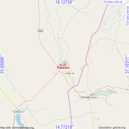
Kassala GPS coordinates[2]
15° 27' 3.564" North, 36° 23' 59.928" East
| Map corner | latitude | longitude |
|---|---|---|
| Upper-left | 16.12758°, | 35.69686° |
| Center: | 15.45099°, | 36.39998° |
| Lower-right: | 14.77218°, | 37.10311° |
| Map W x H: | 150.7×150.7 km | = 93.6×93.6mi |
| max Lat: | 21.06667° ⇑28.2% North |
| Kassala: | 15.45099° |
| min Lat: | ⇓71.8% South 10.55° |
| min Long | Kassala | max Long |
| 22.44725° | 36.39998° | 37.729° |
| W 95.8%⇐ | ⇒4.2% E |
Elevation
Elevation of Kassala is 507 m = 1663 ft, and this is 57.9 m = 190 ft above average elevation for this country.
| Max E: |
1159 m = 3802 ft | 25.4% |
| Kassala | 507 m 1663 ft | |
| Avg. | 449.1 m = 1473 ft | |
Min E: |
4 m = 13 ft | 74.6% |
See also: Kassala elevation on elevation.city.
Geographical zone
Kassala is located in North Torrid zone (between Equator and Tropic of Cancer). Distance of this Northern Tropic circle is 887.9 km =551.7 mi to North.| Distance of | km | miles | from Kassala |
|---|---|---|---|
| North Pole | 8289.1 | 5150.6 | to North |
| Arctic Circle | 5683.2 | 3531.4 | to North |
| Tropic Cancer | 887.9 | 551.7 | to North |
| Equator | 1718 | 1067.5 | to South |


Nearby cities:
15 places around Kassala: (largest is in red/bold)
• Ad Dindar
347.2 km =215.7 mi,  223°
223°
• Al Hasaheisa
341.9 km =212.4 mi,  256°
256°
• Al Hilāliyya
344.4 km =214 mi, 260°
• Al Masallamiyya
343 km =213.1 mi,  253°
253°
• Al Qadarif
191.7 km =119.1 mi,  214°
214°
• Al Ḩawātah
295.5 km =183.6 mi, 220°
• Aroma
49.7 km =30.9 mi,  324°
324°
• Atbara
358.9 km =223 mi,  314°
314°
• Doka
225.6 km =140.2 mi,  197°
197°
• Ed Damer
352.2 km =218.8 mi, 312°
• El Matama
354 km =220 mi,  293°
293°
• Shendi
345.6 km =214.7 mi, 293°
• Wad Medani
330.7 km =205.5 mi, 249°
• Wad Rāwah
351.1 km =218.2 mi, 264°
• Wagar
80.8 km =50.2 mi,  344°
344°
Sources, notices
• [Note1] Compared only with cities in Sudan existing in our database
• [Src1] Map data: © OpenStreetMap contributors (CC-BY-SA)
• [Src2] Other city data from geonames.org with taken over terms of usage.
• [Src3] Geographical zone / Annual Mean Temperature by Robert A. Rohde @ Wikipedia
