Bergshammar geodata
Bergshammar (Södermanland) is a populated place; located in Sweden in Europe/Stockholm (GMT+2) time zone. With population of 801 people, there are 964 cities with bigger population in this country. Compared to other cities in Sweden, 51.1% of cities are located further ↓South; 72.8% of cities are located further ←West and 71.8% of cities have higher elevation than Bergshammar. Note1


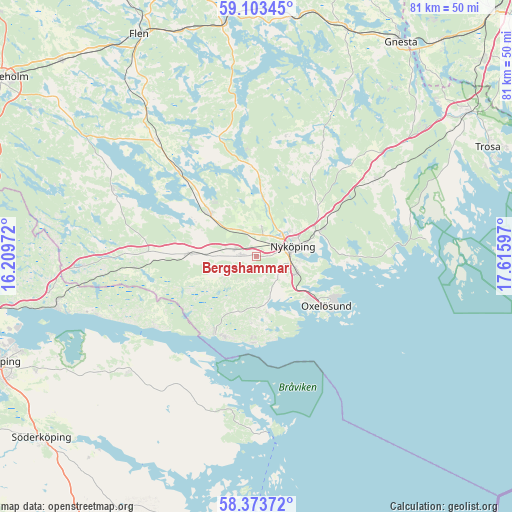
Bergshammar GPS coordinates[2]
58° 44' 25.8" North, 16° 54' 46.224" East
| Map corner | latitude | longitude |
|---|---|---|
| Upper-left | 59.10345°, | 16.20972° |
| Center: | 58.7405°, | 16.91284° |
| Lower-right: | 58.37372°, | 17.61597° |
| Map W x H: | 81.1×81.1 km | = 50.4×50.4mi |
| max Lat: | 67.85572° ⇑48.9% North |
| Bergshammar: | 58.7405° |
| min Lat: | ⇓51.1% South 55.34337° |
| min Long | Bergshammar | max Long |
| 11.1712° | 16.91284° | 24.13676° |
| W 72.8%⇐ | ⇒27.2% E |
Elevation
Elevation of Bergshammar is 23 m = 75 ft, and this is 59.6 m = 196 ft below average elevation for this country.
| Max E: |
663 m = 2175 ft | 71.8% |
| Avg. | 82.6 m = 271 ft | |
| Bergshammar | 23 m = 75 ft | |
Min E: |
-1 m = -3 ft | 28.2% |
See also: Sweden elevation on elevation.city.
Geographical zone
Bergshammar is located in North temperate zone (between Tropic of Cancer and the Arctic Circle). Distance of this North polar circle is 869.8 km =540.5 mi to North.| Distance of | km | miles | from Bergshammar |
|---|---|---|---|
| North Pole | 3475.7 | 2159.7 | to North |
| Arctic Circle | 869.8 | 540.5 | to North |
| Tropic Cancer | 3925.4 | 2439.1 | to South |
| Equator | 6531.3 | 4058.4 | to South |


Nearby cities:
15 places around Bergshammar: (largest is in red/bold)
• Arnö
6.6 km =4.1 mi,  103°
103°
• Bara
10.9 km =6.8 mi,  125°
125°
• Jönåker
11.2 km =7 mi,  272°
272°
• Krokek
32.4 km =20.1 mi,  256°
256°
• Nyköping
5.7 km =3.5 mi,  75°
75°
• Nävekvarn
13.6 km =8.5 mi,  208°
208°
• Olstorp
18.2 km =11.3 mi,  297°
297°
• Oxelösund
13.4 km =8.3 mi, 125°
• Sparreholm
36.7 km =22.8 mi,  351°
351°
• Stigtomta
10 km =6.2 mi,  311°
311°
• Strömsfors
34.3 km =21.3 mi, 258°
• Svalsta
2.5 km =1.6 mi,  275°
275°
• Tystberga
22.1 km =13.7 mi,  56°
56°
• Vrena
18.2 km =11.3 mi,  317°
317°
• Östra Husby
27.3 km =17 mi,  230°
230°
Sources, notices
• [Note1] Compared only with cities in Sweden existing in our database
• [Src1] Map data: © OpenStreetMap contributors (CC-BY-SA)
• [Src2] Other city data from geonames.org with taken over terms of usage.
• [Src3] Geographical zone / Annual Mean Temperature by Robert A. Rohde @ Wikipedia
