Svalsta geodata
Svalsta (Södermanland) is a populated place; located in Sweden in Europe/Stockholm (GMT+2) time zone. With population of 1,095 people, there are 772 cities with bigger population in this country. Compared to other cities in Sweden, 51.2% of cities are located further ↓South; 72.4% of cities are located further ←West and 65.3% of cities have higher elevation than Svalsta. Note1


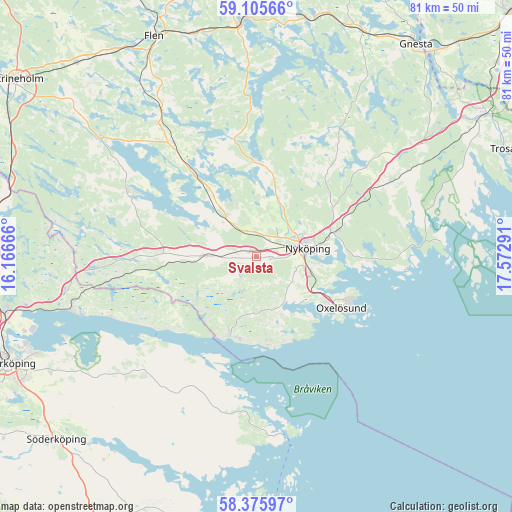
Svalsta GPS coordinates[2]
58° 44' 33.828" North, 16° 52' 11.208" East
| Map corner | latitude | longitude |
|---|---|---|
| Upper-left | 59.10566°, | 16.16666° |
| Center: | 58.74273°, | 16.86978° |
| Lower-right: | 58.37597°, | 17.57291° |
| Map W x H: | 81.1×81.1 km | = 50.4×50.4mi |
| max Lat: | 67.85572° ⇑48.8% North |
| Svalsta: | 58.74273° |
| min Lat: | ⇓51.2% South 55.34337° |
| min Long | Svalsta | max Long |
| 11.1712° | 16.86978° | 24.13676° |
| W 72.4%⇐ | ⇒27.6% E |
Elevation
Elevation of Svalsta is 30 m = 98 ft, and this is 52.6 m = 173 ft below average elevation for this country.
| Max E: |
663 m = 2175 ft | 65.3% |
| Avg. | 82.6 m = 271 ft | |
| Svalsta | 30 m = 98 ft | |
Min E: |
-1 m = -3 ft | 34.7% |
See also: Sweden elevation on elevation.city.
Geographical zone
Svalsta is located in North temperate zone (between Tropic of Cancer and the Arctic Circle). Distance of this North polar circle is 869.6 km =540.3 mi to North.| Distance of | km | miles | from Svalsta |
|---|---|---|---|
| North Pole | 3475.5 | 2159.6 | to North |
| Arctic Circle | 869.6 | 540.3 | to North |
| Tropic Cancer | 3925.7 | 2439.3 | to South |
| Equator | 6531.6 | 4058.5 | to South |


Nearby cities:
15 places around Svalsta: (largest is in red/bold)
• Arnö
9 km =5.6 mi,  101°
101°
• Bara
13.1 km =8.1 mi,  120°
120°
• Bergshammar
2.5 km =1.6 mi, 95°
• Jönåker
8.7 km =5.4 mi,  271°
271°
• Krokek
30.1 km =18.7 mi,  254°
254°
• Nyköping
8 km =5 mi,  81°
81°
• Nävekvarn
12.8 km =8 mi,  198°
198°
• Olstorp
15.9 km =9.9 mi,  301°
301°
• Oxelösund
15.6 km =9.7 mi, 120°
• Sparreholm
36.1 km =22.4 mi,  355°
355°
• Stigtomta
8.1 km =5 mi,  321°
321°
• Strömsfors
31.9 km =19.8 mi,  257°
257°
• Tystberga
24.1 km =15 mi,  60°
60°
• Vrena
16.4 km =10.2 mi, 323°
• Östra Husby
25.6 km =15.9 mi,  226°
226°
Sources, notices
• [Note1] Compared only with cities in Sweden existing in our database
• [Src1] Map data: © OpenStreetMap contributors (CC-BY-SA)
• [Src2] Other city data from geonames.org with taken over terms of usage.
• [Src3] Geographical zone / Annual Mean Temperature by Robert A. Rohde @ Wikipedia
