Jönåker geodata
Jönåker (Södermanland) is a populated place; located in Sweden in Europe/Stockholm (GMT+2) time zone. With population of 598 people, there are 1178 cities with bigger population in this country. Compared to other cities in Sweden, 51.3% of cities are located further ↓South; 71.5% of cities are located further ←West and 88.4% of cities have higher elevation than Jönåker. Note1


Jönåker GPS coordinates[2]
58° 44' 39.624" North, 16° 43' 10.092" East
| Map corner | latitude | longitude |
|---|---|---|
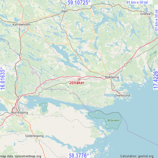
| Upper-left | 59.10725°, | 16.01635° |
| Center: | 58.74434°, | 16.71947° |
| Lower-right: | 58.3776°, | 17.4226° |
| Map W x H: | 81.1×81.1 km | = 50.4×50.4mi |
| max Lat: | 67.85572° ⇑48.7% North |
| Jönåker: | 58.74434° |
| min Lat: | ⇓51.3% South 55.34337° |
| min Long | Jönåker | max Long |
| 11.1712° | 16.71947° | 24.13676° |
| W 71.5%⇐ | ⇒28.5% E |
Elevation
Elevation of Jönåker is 10 m = 33 ft, and this is 72.6 m = 238 ft below average elevation for this country.
| Max E: |
663 m = 2175 ft | 88.4% |
| Avg. | 82.6 m = 271 ft | |
| Jönåker | 10 m = 33 ft | |
Min E: |
-1 m = -3 ft | 11.6% |
See also: Sweden elevation on elevation.city.
Geographical zone
Jönåker is located in North temperate zone (between Tropic of Cancer and the Arctic Circle). Distance of this North polar circle is 869.4 km =540.2 mi to North.| Distance of | km | miles | from Jönåker |
|---|---|---|---|
| North Pole | 3475.3 | 2159.5 | to North |
| Arctic Circle | 869.4 | 540.2 | to North |
| Tropic Cancer | 3925.8 | 2439.4 | to South |
| Equator | 6531.8 | 4058.7 | to South |


Nearby cities:
15 places around Jönåker: (largest is in red/bold)
• Arnö
17.6 km =10.9 mi,  96°
96°
• Bara
21.2 km =13.2 mi,  108°
108°
• Bergshammar
11.2 km =7 mi,  92°
92°
• Krokek
21.9 km =13.6 mi,  248°
248°
• Lindö
30.6 km =19 mi,  242°
242°
• Nyköping
16.7 km =10.4 mi, 86°
• Nävekvarn
13.2 km =8.2 mi,  159°
159°
• Olstorp
9.5 km =5.9 mi,  328°
328°
• Oxelösund
23.5 km =14.6 mi, 110°
• Stigtomta
7.2 km =4.5 mi,  30°
30°
• Strömsfors
23.6 km =14.7 mi, 252°
• Svalsta
8.7 km =5.4 mi, 91°
• Tystberga
31.8 km =19.8 mi,  68°
68°
• Vrena
13 km =8.1 mi,  354°
354°
• Östra Husby
20.4 km =12.7 mi,  208°
208°
Sources, notices
• [Note1] Compared only with cities in Sweden existing in our database
• [Src1] Map data: © OpenStreetMap contributors (CC-BY-SA)
• [Src2] Other city data from geonames.org with taken over terms of usage.
• [Src3] Geographical zone / Annual Mean Temperature by Robert A. Rohde @ Wikipedia
