Nyköping geodata
Nyköping (Södermanland) is a seat of a first-order administrative division; located in Sweden in Europe/Stockholm (GMT+2) time zone. With population of 32,224 people, there are 50 cities with bigger population in this country. Compared to other cities in Sweden, 51.4% of cities are located further ↓South; 73.7% of cities are located further ←West and 75.3% of cities have higher elevation than Nyköping. Note1


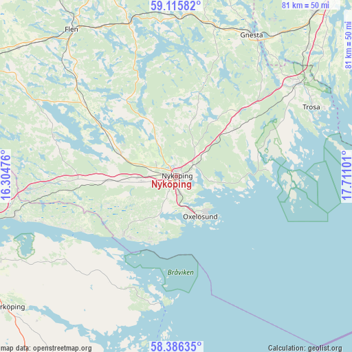
Nyköping GPS coordinates[2]
58° 45' 10.8" North, 17° 0' 28.368" East
| Map corner | latitude | longitude |
|---|---|---|
| Upper-left | 59.11582°, | 16.30476° |
| Center: | 58.753°, | 17.00788° |
| Lower-right: | 58.38635°, | 17.71101° |
| Map W x H: | 81.1×81.1 km | = 50.4×50.4mi |
| max Lat: | 67.85572° ⇑48.6% North |
| Nyköping: | 58.753° |
| min Lat: | ⇓51.4% South 55.34337° |
| min Long | Nyköping | max Long |
| 11.1712° | 17.00788° | 24.13676° |
| W 73.7%⇐ | ⇒26.3% E |
Elevation
Elevation of Nyköping is 20 m = 66 ft, and this is 62.6 m = 205 ft below average elevation for this country.
| Max E: |
663 m = 2175 ft | 75.3% |
| Avg. | 82.6 m = 271 ft | |
| Nyköping | 20 m = 66 ft | |
Min E: |
-1 m = -3 ft | 24.7% |
See also: Sweden elevation on elevation.city.
Geographical zone
Nyköping is located in North temperate zone (between Tropic of Cancer and the Arctic Circle). Distance of this North polar circle is 868.5 km =539.7 mi to North.| Distance of | km | miles | from Nyköping |
|---|---|---|---|
| North Pole | 3474.3 | 2158.8 | to North |
| Arctic Circle | 868.5 | 539.7 | to North |
| Tropic Cancer | 3926.8 | 2440 | to South |
| Equator | 6532.7 | 4059.2 | to South |


Nearby cities:
15 places around Nyköping: (largest is in red/bold)
• Arnö
3 km =1.9 mi,  163°
163°
• Bara
8.5 km =5.3 mi, 156°
• Bergshammar
5.7 km =3.5 mi,  255°
255°
• Björnlunda
35.7 km =22.2 mi,  14°
14°
• Jönåker
16.7 km =10.4 mi,  266°
266°
• Nävekvarn
17.9 km =11.1 mi,  222°
222°
• Olstorp
22.7 km =14.1 mi,  288°
288°
• Oxelösund
10.6 km =6.6 mi,  149°
149°
• Stigtomta
14 km =8.7 mi, 291°
• Svalsta
8 km =5 mi, 261°
• Trosa
34.9 km =21.7 mi,  62°
62°
• Tystberga
16.9 km =10.5 mi,  50°
50°
• Vagnhärad
34.9 km =21.7 mi, 52°
• Vrena
21.4 km =13.3 mi,  304°
304°
• Östra Husby
32.5 km =20.2 mi,  234°
234°
Sources, notices
• [Note1] Compared only with cities in Sweden existing in our database
• [Src1] Map data: © OpenStreetMap contributors (CC-BY-SA)
• [Src2] Other city data from geonames.org with taken over terms of usage.
• [Src3] Geographical zone / Annual Mean Temperature by Robert A. Rohde @ Wikipedia
