Vilhelmina geodata
Vilhelmina (Västerbotten) is a seat of a second-order administrative division; located in Sweden in Europe/Stockholm (GMT+2) time zone. With population of 3,572 people, there are 359 cities with bigger population in this country. Compared to other cities in Sweden, 94.4% of cities are located further ↓South; 71% of cities are located further ←West and 97.9% of cities have lower elevation than Vilhelmina. Note1
Administrative division(s):
- Level 1: Västerbotten
- Level 2: Vilhelmina Kommun
- Level 3: Vilhelmina
- Level 4: Vilhelmina socken


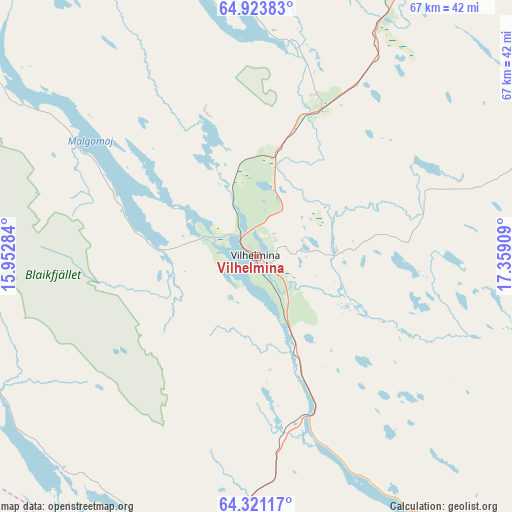
Vilhelmina GPS coordinates[2]
64° 37' 27.012" North, 16° 39' 21.456" East
| Map corner | latitude | longitude |
|---|---|---|
| Upper-left | 64.92383°, | 15.95284° |
| Center: | 64.62417°, | 16.65596° |
| Lower-right: | 64.32117°, | 17.35909° |
| Map W x H: | 67×67 km | = 41.6×41.6mi |
| max Lat: | 67.85572° ⇑5.6% North |
| Vilhelmina: | 64.62417° |
| min Lat: | ⇓94.4% South 55.34337° |
| min Long | Vilhelmina | max Long |
| 11.1712° | 16.65596° | 24.13676° |
| W 71%⇐ | ⇒29% E |
Elevation
Elevation of Vilhelmina is 349 m = 1145 ft, and this is 266.4 m = 874 ft above average elevation for this country.
| Max E: |
663 m = 2175 ft | 2.1% |
| Vilhelmina | 349 m 1145 ft | |
| Avg. | 82.6 m = 271 ft | |
Min E: |
-1 m = -3 ft | 97.9% |
See also: Sweden elevation on elevation.city.
Geographical zone
Vilhelmina is located in North temperate zone (between Tropic of Cancer and the Arctic Circle). Distance of this North polar circle is 215.6 km =134 mi to North.| Distance of | km | miles | from Vilhelmina |
|---|---|---|---|
| North Pole | 2821.5 | 1753.2 | to North |
| Arctic Circle | 215.6 | 134 | to North |
| Tropic Cancer | 4579.6 | 2845.6 | to South |
| Equator | 7185.5 | 4464.9 | to South |


Nearby cities:
15 places around Vilhelmina: (largest is in red/bold)
• Backe
90.6 km =56.3 mi,  187°
187°
• Björkvik
110 km =68.4 mi,  332°
332°
• Dorotea
41.9 km =26 mi,  196°
196°
• Hoting
60.8 km =37.8 mi, 200°
• Insjön
46.8 km =29.1 mi,  122°
122°
• Junsele
103.8 km =64.5 mi,  173°
173°
• Lycksele
96.2 km =59.8 mi,  91°
91°
• Malå
116.5 km =72.4 mi,  57°
57°
• Sorsele
109.3 km =67.9 mi,  22°
22°
• Storuman
56.8 km =35.3 mi, 22°
• Strömsund
101 km =62.8 mi,  211°
211°
• Söderfors
69.6 km =43.2 mi,  72°
72°
• Sörvik
70.8 km =44 mi,  219°
219°
• Tallåsen
110.4 km =68.6 mi,  109°
109°
• Åsele
61.4 km =38.2 mi,  147°
147°
Sources, notices
• [Note1] Compared only with cities in Sweden existing in our database
• [Src1] Map data: © OpenStreetMap contributors (CC-BY-SA)
• [Src2] Other city data from geonames.org with taken over terms of usage.
• [Src3] Geographical zone / Annual Mean Temperature by Robert A. Rohde @ Wikipedia
