Södra Vi geodata
Södra Vi (Kalmar) is a populated place; located in Sweden in Europe/Stockholm (GMT+2) time zone. With population of 1,134 people, there are 762 cities with bigger population in this country. Compared to other cities in Sweden, 65.9% of cities are located further ↑North; 59.4% of cities are located further ←West and 76.4% of cities have lower elevation than Södra Vi. Note1


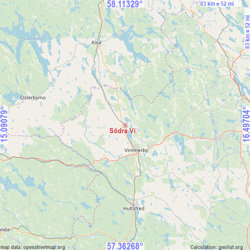
Södra Vi GPS coordinates[2]
57° 44' 23.748" North, 15° 47' 38.076" East
| Map corner | latitude | longitude |
|---|---|---|
| Upper-left | 58.11329°, | 15.09079° |
| Center: | 57.73993°, | 15.79391° |
| Lower-right: | 57.36268°, | 16.49704° |
| Map W x H: | 83.5×83.5 km | = 51.9×51.9mi |
| max Lat: | 67.85572° ⇑65.9% North |
| Södra Vi: | 57.73993° |
| min Lat: | ⇓34.1% South 55.34337° |
| min Long | Södra Vi | max Long |
| 11.1712° | 15.79391° | 24.13676° |
| W 59.4%⇐ | ⇒40.6% E |
Elevation
Elevation of Södra Vi is 125 m = 410 ft, and this is 42.4 m = 139 ft above average elevation for this country.
| Max E: |
663 m = 2175 ft | 23.6% |
| Södra Vi | 125 m 410 ft | |
| Avg. | 82.6 m = 271 ft | |
Min E: |
-1 m = -3 ft | 76.4% |
See also: Sweden elevation on elevation.city.
Geographical zone
Södra Vi is located in North temperate zone (between Tropic of Cancer and the Arctic Circle). Distance of this North polar circle is 981.1 km =609.6 mi to North.| Distance of | km | miles | from Södra Vi |
|---|---|---|---|
| North Pole | 3587 | 2228.9 | to North |
| Arctic Circle | 981.1 | 609.6 | to North |
| Tropic Cancer | 3814.2 | 2370 | to South |
| Equator | 6420.1 | 3989.3 | to South |


Nearby cities:
15 places around Södra Vi: (largest is in red/bold)
• Ankarsrum
32.4 km =20.1 mi,  98°
98°
• Gamleby
40.1 km =24.9 mi,  64°
64°
• Gullringen
8.7 km =5.4 mi,  320°
320°
• Horn
18 km =11.2 mi,  7°
7°
• Hultsfred
28.2 km =17.5 mi,  173°
173°
• Järnforsen
37.5 km =23.3 mi,  196°
196°
• Kisa
29.2 km =18.1 mi,  340°
340°
• Lidhult
33 km =20.5 mi, 315°
• Mariannelund
19.2 km =11.9 mi,  224°
224°
• Målilla
39.2 km =24.4 mi,  178°
178°
• Silverdalen
22.3 km =13.9 mi,  186°
186°
• Storebro
17.7 km =11 mi, 169°
• Vimmerby
9 km =5.6 mi,  156°
156°
• Österbymo
32.3 km =20.1 mi,  286°
286°
• Överum
41.4 km =25.7 mi,  48°
48°
Sources, notices
• [Note1] Compared only with cities in Sweden existing in our database
• [Src1] Map data: © OpenStreetMap contributors (CC-BY-SA)
• [Src2] Other city data from geonames.org with taken over terms of usage.
• [Src3] Geographical zone / Annual Mean Temperature by Robert A. Rohde @ Wikipedia
