Gullringen geodata
Gullringen (Kalmar) is a populated place; located in Sweden in Europe/Stockholm (GMT+2) time zone. With population of 503 people, there are 1307 cities with bigger population in this country. Compared to other cities in Sweden, 64.3% of cities are located further ↑North; 58.1% of cities are located further ←West and 78.8% of cities have lower elevation than Gullringen. Note1


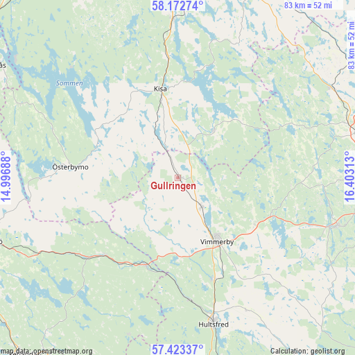
Gullringen GPS coordinates[2]
57° 48' 0" North, 15° 42' 0" East
| Map corner | latitude | longitude |
|---|---|---|
| Upper-left | 58.17274°, | 14.99688° |
| Center: | 57.8°, | 15.7° |
| Lower-right: | 57.42337°, | 16.40313° |
| Map W x H: | 83.3×83.3 km | = 51.8×51.8mi |
| max Lat: | 67.85572° ⇑64.3% North |
| Gullringen: | 57.8° |
| min Lat: | ⇓35.7% South 55.34337° |
| min Long | Gullringen | max Long |
| 11.1712° | 15.7° | 24.13676° |
| W 58.1%⇐ | ⇒41.9% E |
Elevation
Elevation of Gullringen is 138 m = 453 ft, and this is 55.4 m = 182 ft above average elevation for this country.
| Max E: |
663 m = 2175 ft | 21.2% |
| Gullringen | 138 m 453 ft | |
| Avg. | 82.6 m = 271 ft | |
Min E: |
-1 m = -3 ft | 78.8% |
See also: Sweden elevation on elevation.city.
Geographical zone
Gullringen is located in North temperate zone (between Tropic of Cancer and the Arctic Circle). Distance of this North polar circle is 974.4 km =605.5 mi to North.| Distance of | km | miles | from Gullringen |
|---|---|---|---|
| North Pole | 3580.3 | 2224.7 | to North |
| Arctic Circle | 974.4 | 605.5 | to North |
| Tropic Cancer | 3820.8 | 2374.1 | to South |
| Equator | 6426.8 | 3993.4 | to South |


Nearby cities:
15 places around Gullringen: (largest is in red/bold)
• Ankarsrum
39.3 km =24.4 mi,  106°
106°
• Gamleby
43 km =26.7 mi,  75°
75°
• Horn
13.6 km =8.5 mi,  35°
35°
• Hultsfred
35.7 km =22.2 mi,  166°
166°
• Järnforsen
42.9 km =26.7 mi,  186°
186°
• Kisa
21.3 km =13.2 mi,  349°
349°
• Lidhult
24.3 km =15.1 mi,  313°
313°
• Mariannelund
21.9 km =13.6 mi,  201°
201°
• Rimforsa
37.4 km =23.2 mi,  358°
358°
• Silverdalen
29 km =18 mi, 173°
• Storebro
25.7 km =16 mi,  159°
159°
• Södra Vi
8.7 km =5.4 mi,  140°
140°
• Vimmerby
17.5 km =10.9 mi,  148°
148°
• Österbymo
25.4 km =15.8 mi,  276°
276°
• Överum
41.9 km =26 mi,  59°
59°
Sources, notices
• [Note1] Compared only with cities in Sweden existing in our database
• [Src1] Map data: © OpenStreetMap contributors (CC-BY-SA)
• [Src2] Other city data from geonames.org with taken over terms of usage.
• [Src3] Geographical zone / Annual Mean Temperature by Robert A. Rohde @ Wikipedia
