Åseda geodata
Åseda (Kronoberg) is a seat of a second-order administrative division; located in Sweden in Europe/Stockholm (GMT+2) time zone. With population of 2,557 people, there are 446 cities with bigger population in this country. Compared to other cities in Sweden, 76% of cities are located further ↑North; 53.9% of cities are located further ←West and 94% of cities have lower elevation than Åseda. Note1


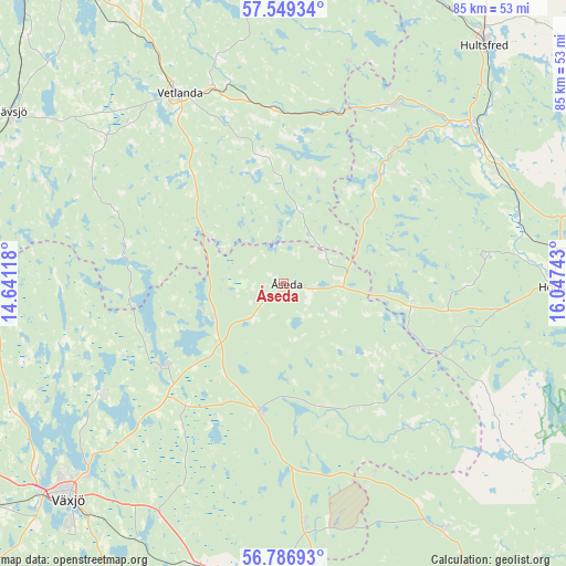
Åseda GPS coordinates[2]
57° 10' 12.36" North, 15° 20' 39.48" East
| Map corner | latitude | longitude |
|---|---|---|
| Upper-left | 57.54934°, | 14.64118° |
| Center: | 57.1701°, | 15.3443° |
| Lower-right: | 56.78693°, | 16.04743° |
| Map W x H: | 84.8×84.8 km | = 52.7×52.7mi |
| max Lat: | 67.85572° ⇑76% North |
| Åseda: | 57.1701° |
| min Lat: | ⇓24% South 55.34337° |
| min Long | Åseda | max Long |
| 11.1712° | 15.3443° | 24.13676° |
| W 53.9%⇐ | ⇒46.1% E |
Elevation
Elevation of Åseda is 238 m = 781 ft, and this is 155.4 m = 510 ft above average elevation for this country.
| Max E: |
663 m = 2175 ft | 6% |
| Åseda | 238 m 781 ft | |
| Avg. | 82.6 m = 271 ft | |
Min E: |
-1 m = -3 ft | 94% |
See also: Sweden elevation on elevation.city.
Geographical zone
Åseda is located in North temperate zone (between Tropic of Cancer and the Arctic Circle). Distance of this North polar circle is 1044.5 km =649 mi to North.| Distance of | km | miles | from Åseda |
|---|---|---|---|
| North Pole | 3650.3 | 2268.2 | to North |
| Arctic Circle | 1044.5 | 649 | to North |
| Tropic Cancer | 3750.8 | 2330.6 | to South |
| Equator | 6356.7 | 3949.9 | to South |


Nearby cities:
15 places around Åseda: (largest is in red/bold)
• Alstermo
28.8 km =17.9 mi,  139°
139°
• Braås
21.2 km =13.2 mi,  237°
237°
• Holsbybrunn
30.5 km =19 mi,  343°
343°
• Hällaryd
34.7 km =21.6 mi, 342°
• Järnforsen
31.9 km =19.8 mi,  30°
30°
• Korsberga
19.8 km =12.3 mi,  318°
318°
• Kosta
36.5 km =22.7 mi,  175°
175°
• Landsbro
34.5 km =21.4 mi,  309°
309°
• Lenhovda
19.3 km =12 mi,  191°
191°
• Myresjö
33.1 km =20.6 mi, 316°
• Mörlunda
34.5 km =21.4 mi,  61°
61°
• Rottne
31.8 km =19.8 mi, 237°
• Skruv
10.9 km =6.8 mi,  258°
258°
• Vetlanda
32.9 km =20.4 mi,  330°
330°
• Virserum
21.7 km =13.5 mi,  41°
41°
Sources, notices
• [Note1] Compared only with cities in Sweden existing in our database
• [Src1] Map data: © OpenStreetMap contributors (CC-BY-SA)
• [Src2] Other city data from geonames.org with taken over terms of usage.
• [Src3] Geographical zone / Annual Mean Temperature by Robert A. Rohde @ Wikipedia
