Mariannelund geodata
Mariannelund (Jönköping) is a populated place; located in Sweden in Europe/Stockholm (GMT+2) time zone. With population of 1,503 people, there are 656 cities with bigger population in this country. Compared to other cities in Sweden, 69.9% of cities are located further ↑North; 56.4% of cities are located further ←West and 80.4% of cities have lower elevation than Mariannelund. Note1


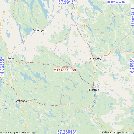
Mariannelund GPS coordinates[2]
57° 37' 0.012" North, 15° 34' 0.012" East
| Map corner | latitude | longitude |
|---|---|---|
| Upper-left | 57.9913°, | 14.86355° |
| Center: | 57.61667°, | 15.56667° |
| Lower-right: | 57.23813°, | 16.2698° |
| Map W x H: | 83.7×83.7 km | = 52×52mi |
| max Lat: | 67.85572° ⇑69.9% North |
| Mariannelund: | 57.61667° |
| min Lat: | ⇓30.1% South 55.34337° |
| min Long | Mariannelund | max Long |
| 11.1712° | 15.56667° | 24.13676° |
| W 56.4%⇐ | ⇒43.6% E |
Elevation
Elevation of Mariannelund is 147 m = 482 ft, and this is 64.4 m = 211 ft above average elevation for this country.
| Max E: |
663 m = 2175 ft | 19.6% |
| Mariannelund | 147 m 482 ft | |
| Avg. | 82.6 m = 271 ft | |
Min E: |
-1 m = -3 ft | 80.4% |
See also: Sweden elevation on elevation.city.
Geographical zone
Mariannelund is located in North temperate zone (between Tropic of Cancer and the Arctic Circle). Distance of this North polar circle is 994.8 km =618.1 mi to North.| Distance of | km | miles | from Mariannelund |
|---|---|---|---|
| North Pole | 3600.7 | 2237.4 | to North |
| Arctic Circle | 994.8 | 618.1 | to North |
| Tropic Cancer | 3800.5 | 2361.5 | to South |
| Equator | 6406.4 | 3980.8 | to South |


Nearby cities:
15 places around Mariannelund: (largest is in red/bold)
• Ekenässjön
35.3 km =21.9 mi,  246°
246°
• Eksjö
35.8 km =22.2 mi,  278°
278°
• Gullringen
21.9 km =13.6 mi,  21°
21°
• Holsbybrunn
29.9 km =18.6 mi,  227°
227°
• Horn
35.3 km =21.9 mi,  26°
26°
• Hultsfred
21.8 km =13.5 mi,  130°
130°
• Hällaryd
29.1 km =18.1 mi,  235°
235°
• Järnforsen
22.4 km =13.9 mi,  172°
172°
• Målilla
29.2 km =18.1 mi,  150°
150°
• Silverdalen
13.8 km =8.6 mi, 127°
• Storebro
17.3 km =10.7 mi,  102°
102°
• Södra Vi
19.2 km =11.9 mi,  44°
44°
• Vimmerby
18 km =11.2 mi,  72°
72°
• Virserum
33.4 km =20.8 mi,  178°
178°
• Österbymo
28.9 km =18 mi,  323°
323°
Sources, notices
• [Note1] Compared only with cities in Sweden existing in our database
• [Src1] Map data: © OpenStreetMap contributors (CC-BY-SA)
• [Src2] Other city data from geonames.org with taken over terms of usage.
• [Src3] Geographical zone / Annual Mean Temperature by Robert A. Rohde @ Wikipedia
