Yengema geodata
Yengema (Eastern Province) is a populated place; located in Sierra Leone in Africa/Freetown (GMT+0) time zone. With population of 11,221 people, there are 18 cities with bigger population in this country. Compared to other cities in Sierra Leone, 77.1% of cities are located further ↓South; 73.5% of cities are located further ←West and 90.4% of cities have lower elevation than Yengema. Note1


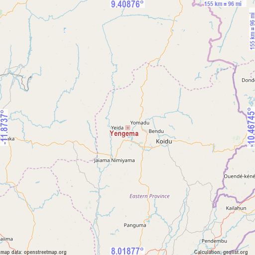
Yengema GPS coordinates[2]
8° 42' 51.876" North, 11° 10' 14.052" West
| Map corner | latitude | longitude |
|---|---|---|
| Upper-left | 9.40876°, | -11.8737° |
| Center: | 8.71441°, | -11.17057° |
| Lower-right: | 8.01877°, | -10.46745° |
| Map W x H: | 154.6×154.6 km | = 96.1×96.1mi |
| max Lat: | 9.91376° ⇑22.9% North |
| Yengema: | 8.71441° |
| min Lat: | ⇓77.1% South 7.24611° |
| min Long | Yengema | max Long |
| -13.28972° | -11.17057° | -10.37135° |
| W 73.5%⇐ | ⇒26.5% E |
Elevation
Elevation of Yengema is 390 m = 1280 ft, and this is 232.8 m = 764 ft above average elevation for this country.
| Max E: |
564 m = 1850 ft | 9.6% |
| Yengema | 390 m 1280 ft | |
| Avg. | 157.2 m = 516 ft | |
Min E: |
1 m = 3 ft | 90.4% |
See also: Sierra Leone elevation on elevation.city.
Geographical zone
Yengema is located in North Torrid zone (between Equator and Tropic of Cancer). Distance of Equator is 969 km =602.1 mi to South.| Distance of | km | miles | from Yengema |
|---|---|---|---|
| North Pole | 9038.1 | 5616 | to North |
| Arctic Circle | 6432.2 | 3996.8 | to North |
| Tropic Cancer | 1637 | 1017.2 | to North |
| Equator | 969 | 602.1 | to South |


Nearby cities:
15 places around Yengema: (largest is in red/bold)
• Alikalia
54.3 km =33.7 mi,  334°
334°
• Barma
44.2 km =27.5 mi,  203°
203°
• Boajibu
61.5 km =38.2 mi, 197°
• Bunumbu
68.9 km =42.8 mi,  150°
150°
• Giehun
22.6 km =14 mi,  141°
141°
• Kayima
19.3 km =12 mi,  3°
3°
• Koidu
23.3 km =14.5 mi,  109°
109°
• Koyima
16.3 km =10.1 mi,  93°
93°
• Makali
54.8 km =34.1 mi,  260°
260°
• Motema
20.6 km =12.8 mi,  122°
122°
• Panguma
59 km =36.7 mi,  175°
175°
• Simbakoro
21.2 km =13.2 mi, 122°
• Tefeya
4.8 km =3 mi, 255°
• Tombu
52 km =32.3 mi, 111°
• Wima
46.2 km =28.7 mi, 184°
Sources, notices
• [Note1] Compared only with cities in Sierra Leone existing in our database
• [Src1] Map data: © OpenStreetMap contributors (CC-BY-SA)
• [Src2] Other city data from geonames.org with taken over terms of usage.
• [Src3] Geographical zone / Annual Mean Temperature by Robert A. Rohde @ Wikipedia
