Simbakoro geodata
Simbakoro (Eastern Province) is a populated place; located in Sierra Leone in Africa/Freetown (GMT+0) time zone. With population of 2,514 people, there are 80 cities with bigger population in this country. Compared to other cities in Sierra Leone, 62.7% of cities are located further ↓South; 84.3% of cities are located further ←West and 94% of cities have lower elevation than Simbakoro. Note1


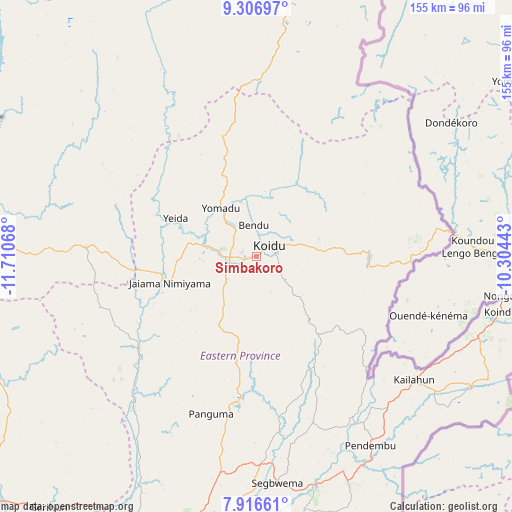
Simbakoro GPS coordinates[2]
8° 36' 44.748" North, 11° 0' 27.18" West
| Map corner | latitude | longitude |
|---|---|---|
| Upper-left | 9.30697°, | -11.71068° |
| Center: | 8.61243°, | -11.00755° |
| Lower-right: | 7.91661°, | -10.30443° |
| Map W x H: | 154.6×154.6 km | = 96.1×96.1mi |
| max Lat: | 9.91376° ⇑37.3% North |
| Simbakoro: | 8.61243° |
| min Lat: | ⇓62.7% South 7.24611° |
| min Long | Simbakoro | max Long |
| -13.28972° | -11.00755° | -10.37135° |
| W 84.3%⇐ | ⇒15.7% E |
Elevation
Elevation of Simbakoro is 403 m = 1322 ft, and this is 245.8 m = 806 ft above average elevation for this country.
| Max E: |
564 m = 1850 ft | 6% |
| Simbakoro | 403 m 1322 ft | |
| Avg. | 157.2 m = 516 ft | |
Min E: |
1 m = 3 ft | 94% |
See also: Sierra Leone elevation on elevation.city.
Geographical zone
Simbakoro is located in North Torrid zone (between Equator and Tropic of Cancer). Distance of Equator is 957.6 km =595 mi to South.| Distance of | km | miles | from Simbakoro |
|---|---|---|---|
| North Pole | 9049.4 | 5623 | to North |
| Arctic Circle | 6443.6 | 4003.9 | to North |
| Tropic Cancer | 1648.3 | 1024.2 | to North |
| Equator | 957.6 | 595 | to South |


Nearby cities:
15 places around Simbakoro: (largest is in red/bold)
• Barma
46 km =28.6 mi,  230°
230°
• Boajibu
59.8 km =37.2 mi,  217°
217°
• Bunumbu
51.2 km =31.8 mi,  162°
162°
• Giehun
7.5 km =4.7 mi,  211°
211°
• Kailahun
60.5 km =37.6 mi,  127°
127°
• Kayima
34.9 km =21.7 mi,  331°
331°
• Koidu
5.3 km =3.3 mi,  48°
48°
• Koyima
10.5 km =6.5 mi,  351°
351°
• Manowa
56.5 km =35.1 mi,  149°
149°
• Motema
0.6 km =0.4 mi,  290°
290°
• Panguma
49.5 km =30.8 mi,  196°
196°
• Tefeya
24.7 km =15.3 mi, 294°
• Tombu
31.4 km =19.5 mi,  104°
104°
• Wima
40.9 km =25.4 mi, 211°
• Yengema
21.2 km =13.2 mi,  302°
302°
Sources, notices
• [Note1] Compared only with cities in Sierra Leone existing in our database
• [Src1] Map data: © OpenStreetMap contributors (CC-BY-SA)
• [Src2] Other city data from geonames.org with taken over terms of usage.
• [Src3] Geographical zone / Annual Mean Temperature by Robert A. Rohde @ Wikipedia
