Koyima geodata
Koyima (Eastern Province) is a populated place; located in Sierra Leone in Africa/Freetown (GMT+0) time zone. With population of 2,705 people, there are 79 cities with bigger population in this country. Compared to other cities in Sierra Leone, 75.9% of cities are located further ↓South; 81.9% of cities are located further ←West and 89.2% of cities have lower elevation than Koyima. Note1


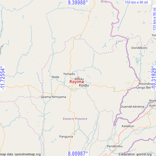
Koyima GPS coordinates[2]
8° 42' 19.872" North, 11° 1' 20.676" West
| Map corner | latitude | longitude |
|---|---|---|
| Upper-left | 9.39988°, | -11.72554° |
| Center: | 8.70552°, | -11.02241° |
| Lower-right: | 8.00987°, | -10.31929° |
| Map W x H: | 154.6×154.6 km | = 96.1×96.1mi |
| max Lat: | 9.91376° ⇑24.1% North |
| Koyima: | 8.70552° |
| min Lat: | ⇓75.9% South 7.24611° |
| min Long | Koyima | max Long |
| -13.28972° | -11.02241° | -10.37135° |
| W 81.9%⇐ | ⇒18.1% E |
Elevation
Elevation of Koyima is 385 m = 1263 ft, and this is 227.8 m = 747 ft above average elevation for this country.
| Max E: |
564 m = 1850 ft | 10.8% |
| Koyima | 385 m 1263 ft | |
| Avg. | 157.2 m = 516 ft | |
Min E: |
1 m = 3 ft | 89.2% |
See also: Sierra Leone elevation on elevation.city.
Geographical zone
Koyima is located in North Torrid zone (between Equator and Tropic of Cancer). Distance of Equator is 968 km =601.5 mi to South.| Distance of | km | miles | from Koyima |
|---|---|---|---|
| North Pole | 9039.1 | 5616.6 | to North |
| Arctic Circle | 6433.2 | 3997.4 | to North |
| Tropic Cancer | 1638 | 1017.8 | to North |
| Equator | 968 | 601.5 | to South |


Nearby cities:
15 places around Koyima: (largest is in red/bold)
• Alikalia
63.9 km =39.7 mi,  321°
321°
• Barma
52.1 km =32.4 mi,  220°
220°
• Bunumbu
61.6 km =38.3 mi,  163°
163°
• Giehun
16.9 km =10.5 mi,  187°
187°
• Kayima
25.2 km =15.7 mi, 323°
• Koidu
8.9 km =5.5 mi,  140°
140°
• Manowa
66.4 km =41.3 mi,  152°
152°
• Motema
10.2 km =6.3 mi,  173°
173°
• Panguma
59.1 km =36.7 mi, 191°
• Seidu
58.4 km =36.3 mi,  53°
53°
• Simbakoro
10.5 km =6.5 mi, 171°
• Tefeya
20.9 km =13 mi,  269°
269°
• Tombu
36.9 km =22.9 mi,  119°
119°
• Wima
49.3 km =30.6 mi,  203°
203°
• Yengema
16.3 km =10.1 mi, 273°
Sources, notices
• [Note1] Compared only with cities in Sierra Leone existing in our database
• [Src1] Map data: © OpenStreetMap contributors (CC-BY-SA)
• [Src2] Other city data from geonames.org with taken over terms of usage.
• [Src3] Geographical zone / Annual Mean Temperature by Robert A. Rohde @ Wikipedia
