Kayima geodata
Kayima (Eastern Province) is a populated place; located in Sierra Leone in Africa/Freetown (GMT+0) time zone. With population of 1,881 people, there are 82 cities with bigger population in this country. Compared to other cities in Sierra Leone, 83.1% of cities are located further ↓South; 75.9% of cities are located further ←West and 85.5% of cities have lower elevation than Kayima. Note1


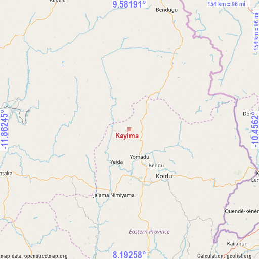
Kayima GPS coordinates[2]
8° 53' 16.44" North, 11° 9' 33.552" West
| Map corner | latitude | longitude |
|---|---|---|
| Upper-left | 9.58191°, | -11.86245° |
| Center: | 8.8879°, | -11.15932° |
| Lower-right: | 8.19258°, | -10.4562° |
| Map W x H: | 154.5×154.5 km | = 96×96mi |
| max Lat: | 9.91376° ⇑16.9% North |
| Kayima: | 8.8879° |
| min Lat: | ⇓83.1% South 7.24611° |
| min Long | Kayima | max Long |
| -13.28972° | -11.15932° | -10.37135° |
| W 75.9%⇐ | ⇒24.1% E |
Elevation
Elevation of Kayima is 373 m = 1224 ft, and this is 215.8 m = 708 ft above average elevation for this country.
| Max E: |
564 m = 1850 ft | 14.5% |
| Kayima | 373 m 1224 ft | |
| Avg. | 157.2 m = 516 ft | |
Min E: |
1 m = 3 ft | 85.5% |
See also: Sierra Leone elevation on elevation.city.
Geographical zone
Kayima is located in North Torrid zone (between Equator and Tropic of Cancer). Distance of Equator is 988.2 km =614 mi to South.| Distance of | km | miles | from Kayima |
|---|---|---|---|
| North Pole | 9018.8 | 5604 | to North |
| Arctic Circle | 6412.9 | 3984.8 | to North |
| Tropic Cancer | 1617.7 | 1005.2 | to North |
| Equator | 988.2 | 614 | to South |


Nearby cities:
15 places around Kayima: (largest is in red/bold)
• Alikalia
38.7 km =24 mi,  319°
319°
• Barma
62.7 km =39 mi,  197°
197°
• Bumbuna
66.7 km =41.4 mi,  285°
285°
• Giehun
39.1 km =24.3 mi,  160°
160°
• Koidu
34.1 km =21.2 mi,  142°
142°
• Koyima
25.2 km =15.7 mi, 143°
• Makali
62.2 km =38.6 mi,  242°
242°
• Masaka
74.9 km =46.5 mi,  250°
250°
• Motema
34.4 km =21.4 mi,  152°
152°
• Seidu
63.7 km =39.6 mi,  76°
76°
• Simbakoro
34.9 km =21.7 mi, 151°
• Tefeya
21.3 km =13.2 mi, 195°
• Tombu
60.9 km =37.8 mi,  129°
129°
• Wima
65.5 km =40.7 mi,  184°
184°
• Yengema
19.3 km =12 mi, 183°
Sources, notices
• [Note1] Compared only with cities in Sierra Leone existing in our database
• [Src1] Map data: © OpenStreetMap contributors (CC-BY-SA)
• [Src2] Other city data from geonames.org with taken over terms of usage.
• [Src3] Geographical zone / Annual Mean Temperature by Robert A. Rohde @ Wikipedia
