Kamakwie geodata
Kamakwie (Northern Province) is a populated place; located in Sierra Leone in Africa/Freetown (GMT+0) time zone. With population of 8,098 people, there are 23 cities with bigger population in this country. Compared to other cities in Sierra Leone, 95.2% of cities are located further ↓South; 73.5% of cities are located further →East and 53% of cities have lower elevation than Kamakwie. Note1


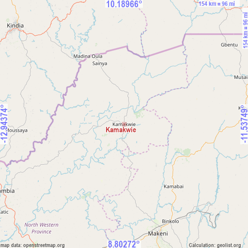
Kamakwie GPS coordinates[2]
9° 29' 48.804" North, 12° 14' 26.196" West
| Map corner | latitude | longitude |
|---|---|---|
| Upper-left | 10.18966°, | -12.94374° |
| Center: | 9.49689°, | -12.24061° |
| Lower-right: | 8.80272°, | -11.53749° |
| Map W x H: | 154.2×154.2 km | = 95.8×95.8mi |
| max Lat: | 9.91376° ⇑4.8% North |
| Kamakwie: | 9.49689° |
| min Lat: | ⇓95.2% South 7.24611° |
| min Long | Kamakwie | max Long |
| -13.28972° | -12.24061° | -10.37135° |
| W 26.5%⇐ | ⇒73.5% E |
Elevation
Elevation of Kamakwie is 116 m = 381 ft, and this is 41.2 m = 135 ft below average elevation for this country.
| Max E: |
564 m = 1850 ft | 47% |
| Avg. | 157.2 m = 516 ft | |
| Kamakwie | 116 m = 381 ft | |
Min E: |
1 m = 3 ft | 53% |
See also: Sierra Leone elevation on elevation.city.
Geographical zone
Kamakwie is located in North Torrid zone (between Equator and Tropic of Cancer). Distance of Equator is 1056 km =656.2 mi to South.| Distance of | km | miles | from Kamakwie |
|---|---|---|---|
| North Pole | 8951.1 | 5562 | to North |
| Arctic Circle | 6345.2 | 3942.7 | to North |
| Tropic Cancer | 1550 | 963.1 | to North |
| Equator | 1056 | 656.2 | to South |


Nearby cities:
15 places around Kamakwie: (largest is in red/bold)
• Alikalia
101.1 km =62.8 mi,  112°
112°
• Bindi
98.6 km =61.3 mi,  61°
61°
• Binkolo
67 km =41.6 mi,  154°
154°
• Bumbuna
74 km =46 mi,  132°
132°
• Kabala
76.1 km =47.3 mi,  82°
82°
• Kambia
85.1 km =52.9 mi,  240°
240°
• Kukuna
47.8 km =29.7 mi,  256°
256°
• Loma
36.9 km =22.9 mi,  37°
37°
• Lunsar
95.9 km =59.6 mi,  199°
199°
• Magburaka
91.8 km =57 mi,  159°
159°
• Makeni
71.3 km =44.3 mi, 162°
• Mange
93 km =57.8 mi,  226°
226°
• Masingbi
85.6 km =53.2 mi, 158°
• Port Loko
101 km =62.8 mi,  216°
216°
• Rokupr
93.2 km =57.9 mi,  189°
189°
Sources, notices
• [Note1] Compared only with cities in Sierra Leone existing in our database
• [Src1] Map data: © OpenStreetMap contributors (CC-BY-SA)
• [Src2] Other city data from geonames.org with taken over terms of usage.
• [Src3] Geographical zone / Annual Mean Temperature by Robert A. Rohde @ Wikipedia
