Akhtarīn geodata
Akhtarīn (Aleppo) is a seat of a third-order administrative division; located in Syria in Asia/Damascus (GMT+3) time zone. In our database, there are 87 cities with bigger population. Compared to other cities in Syria, 90.1% of cities are located further ↓South; 77% of cities are located further ←West and 50.5% of cities have lower elevation than Akhtarīn. Note1


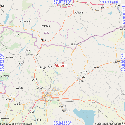
Akhtarīn GPS coordinates[2]
36° 30' 38.592" North, 37° 20' 8.556" East
| Map corner | latitude | longitude |
|---|---|---|
| Upper-left | 37.07379°, | 36.63259° |
| Center: | 36.51072°, | 37.33571° |
| Lower-right: | 35.94353°, | 38.03884° |
| Map W x H: | 125.7×125.7 km | = 78.1×78.1mi |
| max Lat: | 37.17701° ⇑9.9% North |
| Akhtarīn: | 36.51072° |
| min Lat: | ⇓90.1% South 32.39332° |
| min Long | Akhtarīn | max Long |
| 35.75572° | 37.33571° | 42.14006° |
| W 77%⇐ | ⇒23% E |
Elevation
Elevation of Akhtarīn is 471 m = 1545 ft, and this is 58.1 m = 191 ft below average elevation for this country.
| Max E: |
1640 m = 5381 ft | 49.5% |
| Avg. | 529.1 m = 1736 ft | |
| Akhtarīn | 471 m = 1545 ft | |
Min E: |
4 m = 13 ft | 50.5% |
See also: Syria elevation on elevation.city.
Geographical zone
Akhtarīn is located in North temperate zone (between Tropic of Cancer and the Arctic Circle). Distance of this Northern Tropic circle is 1453.7 km =903.3 mi to South.| Distance of | km | miles | from Akhtarīn |
|---|---|---|---|
| North Pole | 5947.5 | 3695.6 | to North |
| Arctic Circle | 3341.6 | 2076.4 | to North |
| Tropic Cancer | 1453.7 | 903.3 | to South |
| Equator | 4059.6 | 2522.5 | to South |


Nearby cities:
15 places around Akhtarīn: (largest is in red/bold)
• Al Bāb
22.4 km =13.9 mi,  134°
134°
• Al Ghandūrah
39.6 km =24.6 mi,  63°
63°
• Al ‘Arīmah
34.7 km =21.6 mi,  96°
96°
• Aleppo
37.8 km =23.5 mi,  204°
204°
• I‘zāz
27.2 km =16.9 mi,  288°
288°
• Kafr Şaghīr
25.3 km =15.7 mi, 196°
• Māri‘
12.8 km =8 mi,  255°
255°
• Nubl
34 km =21.1 mi,  244°
244°
• Sharān
37.8 km =23.5 mi, 289°
• Tall Rif‘at
22 km =13.7 mi, 258°
• Tchoban Bey
15.1 km =9.4 mi,  41°
41°
• Tādif
25.1 km =15.6 mi,  135°
135°
• Şūrān
12.6 km =7.8 mi,  299°
299°
• Ḩuraytān
33.4 km =20.8 mi,  222°
222°
• ‘Afrīn
41.7 km =25.9 mi,  270°
270°
Sources, notices
• [Note1] Compared only with cities in Syria existing in our database
• [Src1] Map data: © OpenStreetMap contributors (CC-BY-SA)
• [Src2] Other city data from geonames.org with taken over terms of usage.
• [Src3] Geographical zone / Annual Mean Temperature by Robert A. Rohde @ Wikipedia
