Sirghāyā geodata
Sirghāyā (Rif-dimashq) is a seat of a third-order administrative division; located in Syria in Asia/Damascus (GMT+3) time zone. In our database, there are 87 cities with bigger population. Compared to other cities in Syria, 76% of cities are located further ↑North; 79.9% of cities are located further →East and 97.9% of cities have lower elevation than Sirghāyā. Note1


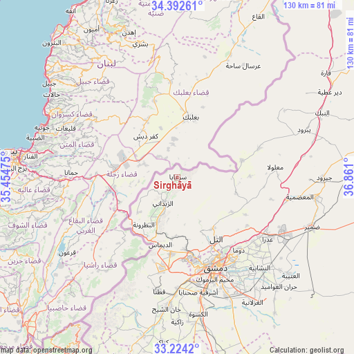
Sirghāyā GPS coordinates[2]
33° 48' 37.44" North, 36° 9' 28.332" East
| Map corner | latitude | longitude |
|---|---|---|
| Upper-left | 34.39261°, | 35.45475° |
| Center: | 33.8104°, | 36.15787° |
| Lower-right: | 33.2242°, | 36.861° |
| Map W x H: | 129.9×129.9 km | = 80.7×80.7mi |
| max Lat: | 37.17701° ⇑76% North |
| Sirghāyā: | 33.8104° |
| min Lat: | ⇓24% South 32.39332° |
| min Long | Sirghāyā | max Long |
| 35.75572° | 36.15787° | 42.14006° |
| W 20.1%⇐ | ⇒79.9% E |
Elevation
Elevation of Sirghāyā is 1367 m = 4485 ft, and this is 837.9 m = 2749 ft above average elevation for this country.
| Max E: |
1640 m = 5381 ft | 2.1% |
| Sirghāyā | 1367 m 4485 ft | |
| Avg. | 529.1 m = 1736 ft | |
Min E: |
4 m = 13 ft | 97.9% |
See also: Syria elevation on elevation.city.
Geographical zone
Sirghāyā is located in North temperate zone (between Tropic of Cancer and the Arctic Circle). Distance of this Northern Tropic circle is 1153.4 km =716.7 mi to South.| Distance of | km | miles | from Sirghāyā |
|---|---|---|---|
| North Pole | 6247.7 | 3882.1 | to North |
| Arctic Circle | 3641.8 | 2262.9 | to North |
| Tropic Cancer | 1153.4 | 716.7 | to South |
| Equator | 3759.4 | 2336 | to South |


Nearby cities:
15 places around Sirghāyā: (largest is in red/bold)
• Ad Dīmās
25.5 km =15.8 mi,  193°
193°
• At Tall
26.4 km =16.4 mi,  147°
147°
• Az Zabadānī
10.9 km =6.8 mi,  209°
209°
• Damascus
35.6 km =22.1 mi,  159°
159°
• Douma
34.9 km =21.7 mi,  139°
139°
• Kafr Baţnā
38.7 km =24 mi, 149°
• Ma‘lūlā
36 km =22.4 mi,  83°
83°
• Medaya
14.3 km =8.9 mi,  200°
200°
• Qadsayyā
29.6 km =18.4 mi,  169°
169°
• Rankūs
22.1 km =13.7 mi,  105°
105°
• Şaydnāyā
23.6 km =14.7 mi,  123°
123°
• Ḩarastā
33.9 km =21.1 mi, 145°
• ‘Assāl al Ward
24.4 km =15.2 mi, 75°
• ‘Ayn al Fījah
21.8 km =13.5 mi, 173°
• ‘Irbīn
36 km =22.4 mi, 147°
Sources, notices
• [Note1] Compared only with cities in Syria existing in our database
• [Src1] Map data: © OpenStreetMap contributors (CC-BY-SA)
• [Src2] Other city data from geonames.org with taken over terms of usage.
• [Src3] Geographical zone / Annual Mean Temperature by Robert A. Rohde @ Wikipedia
